
Updated on 04/05/2024
Dear reader,
I would also like to recommend our Colombia travel guide, which provides a perfect overview of the tourist attractions in Colombia. Enjoy reading it!
In this guide, we present the Chía-Tabio hiking route, one of the best routes in the municipality of Chía, in Cundinamarca.
Content
ToggleWhat is the Chía – Tabio Trail?
The Chía–Tabio Trail is a path that crosses the western mountain of the municipality of Chía. It is also called Cerro de Lourdes. There is a record of this area almost since the arrival of the Spaniards, led by Gonzalo Jiménez de Quesada in 1537.
This hiking route covers the entire Cerro de Lourdes until reaching the Main Park of Tabio, another municipality in Cundinamarca.
These are the main points you will pass through:
- Parador At the Foot of the Mountain MTB
- The Lourdes Viewpoint
- The Lourdes Cross
- The Lourdes Peak
- Main Park of Tabio
This route has a total distance of about 7 km, takes almost 2 hours to complete. However, by walking through these main points, you can have breakfast, take photos, have lunch, walk around the park, and visit its various shops.
So, along with these activities, the round trip could take about 7 hours. This route can be done in the following 3 stages.
This is the rubric that will explain the difficulty level that will appear in each section.
Difficulty level: Moderate
Distance to the next point: 3.3 km (1 mile)
Altitude: 2,564 meters (8,411 feet)
Climate: Temperate climate (10°C to 20°C / 50°F to 68°F)
Route: https://maps.app.goo.gl/XucAZ3H6ssQ4y3aA8
At the Parador At the Foot of the Mountain MTB, or Parador Al pie de la Montaña MTB in Spanish, is a small stop at the entrance of the Chía – Tabio route by Cerro de Lourdes. It is located in the Tiquiza district of Chía and serves as a well-known reference point.
If you are coming from Bogotá by public transport, you could take the B74, B75, or B23 Transmilenio routes to Portal Norte, then take an intermunicipal bus to Chía. Once you arrive in Chía, get off at Paradero de Fonquetá and take a bus to Tiquiza; a few minutes later, get off at this stop.
This part of Chía will captivate you with its interesting blend of rural and urban atmospheres. Moreover, if you enjoy mountain biking, this is the ideal place.
Before starting the walk, which I recommend doing around 8 am, you can park your vehicle (if you have one) at this stop and have a typical breakfast. In fact, in this entire area, you will find various gastronomic offers and local shops.
On the way to our next stage, you will first come across the Lourdes viewpoint, where besides enjoying the incredible panoramic view, you can exercise because there are some machines for that.
Meters later, you will see the imposing and tall Lourdes Cross, a place frequently visited by believers during dates such as Holy Week. I recommend taking a break there.
The Chía–Tabio Trail is a path that crosses the western mountain of the municipality of Chía. It is also called Cerro de Lourdes. There is a record of this area almost since the arrival of the Spaniards, led by Gonzalo Jiménez de Quesada in 1537.
This hiking route covers the entire Cerro de Lourdes until reaching the Main Park of Tabio, another municipality in Cundinamarca.
These are the main points you will pass through:
- Parador Al pie de la Montaña MTB (Parador At the Foot of the Mountain MTB)
- El Mirador de Lourdes (The Lourdes Viewpoint)
- La Cruz de Lourdes (The Lourdes Cross)
- La Cima de Lourdes (The Lourdes Summit)
- Parque Principal de Tabio (Main Park of Tabio)
This route has a total distance of about 7 km, takes almost 2 hours to complete. However, by walking through these main points, you can have breakfast, take photos, have lunch, walk around the park, and visit its various shops.
So, along with these activities, the round trip could take about 7 hours. This route can be done in the following 3 stages.
This is the rubric that will explain the difficulty level that will appear in each section.
Difficulty levels
Moderate
The terrain is flat, asphalted or paved and clearly marked. It is not very long and does not require excessive physical effort. Suitable for the whole family.
Medium
The terrain is mostly uncovered, there is unevenness, moisture and mud. The route requires significant physical effort and is not suitable for people with reduced mobility.
Difficult
The terrain is largely uncovered, there are steep climbs, uncertain weather conditions and high physical demands. The route is usually long and not suitable for the elderly, those with heart and respiratory diseases, children under 8 years old or pregnant women.
How to Navigate the Chía–Tabio Trail? Guide Step by Step
To walk this route, you don’t need to be an expert, just have good physical condition. It’s essential to have planned the excursion in advance and carry the necessary equipment, especially if you are a tourist.
Route: https://maps.app.goo.gl/Y2nz8zckqfWAsk7d9
Stage 1 of the Trail: Parador Al pie de la Montaña MTB
Difficulty level: Moderate
Distance to the next point: 3.3 km (1 mile)
Altitude: 2,564 meters (8,411 feet)
Climate: Temperate climate (10°C to 20°C / 50°F to 68°F)
Route: https://maps.app.goo.gl/XucAZ3H6ssQ4y3aA8
At the Parador Al pie de la Montaña MTB is a small stop at the entrance of the Chía – Tabio route by Cerro de Lourdes. It is located in the Tiquiza district of Chía and serves as a well-known reference point.
If you are coming from Bogotá by public transport, you could take the B74, B75, or B23 Transmilenio routes to Portal Norte, then take an intermunicipal bus to Chía. Once you arrive in Chía, get off at Paradero de Fonquetá and take a bus to Tiquiza; a few minutes later, get off at this stop.
This part of Chía will captivate you with its interesting blend of rural and urban atmospheres. Moreover, if you enjoy mountain biking, this is the ideal place.
Before starting the walk, which I recommend doing around 8 am, you can park your vehicle (if you have one) at this stop and have a typical breakfast. In fact, in this entire area, you will find various gastronomic offers and local shops.
On the way to our next stage, you will first come across the Lourdes viewpoint, where besides enjoying the incredible panoramic view, you can exercise because there are some machines for that.
Meters later, you will see the imposing and tall Lourdes Cross, a place frequently visited by believers during dates such as Holy Week. I recommend taking a break there.
Stage 2 of the Trail: Lourdes Peak
Difficulty level: Moderate
Distance to the next point: 3.4 km (2 miles)
Altitude reached: 2,860 meters (9,383 feet)
Climate: Temperate climate (10°C to 20°C / 50°F to 68°F)
Route: https://maps.app.goo.gl/4kDesvpuB8bveKW77
The Lourdes Peak, or Cima de Lourdes in Spanish, is the end of the ascent, so at this point, you will see a sign that says: “Bienvenido a Tabio” (Welcome to Tabio). This part is used as a hydration zone, so there are stalls where you can buy drinks, even food.
After hydrating, you can start descending towards the Main Park of Tabio; the entire path is framed by a picturesque landscape of farms, typical houses, and huge trees.
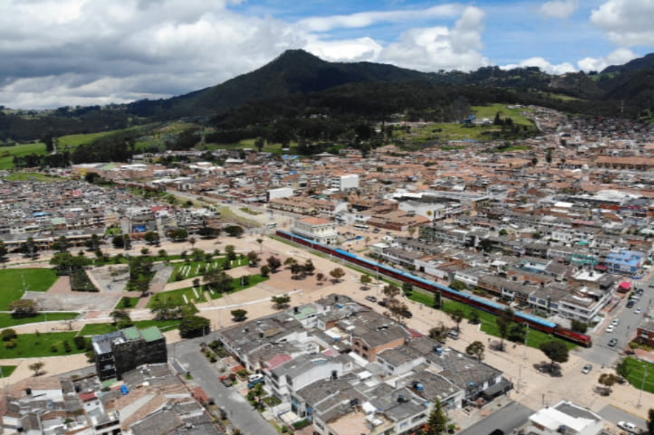
Final Stage of the Trail: Main Park of Tabio
Difficulty level: Moderate
Distance traveled: Almost 7 km (4.349 miles)
Altitude: 2,569 meters (8,428 feet)
Climate: Temperate climate (10°C to 20°C / 50°F to 68°F)
The trail to the Main Park of Tabio is very flat and easy to walk; you can enjoy the landscape peacefully as you reach the final destination. Once at the Main Park, the cobblestone streets will guide you to various shops selling clothing, food, animals, etc.
There, you can have lunch. There are various options, for example, vegetarian, vegan, or international cuisine such as Japanese or Mexican.
After this, you can take the same route back to the starting point.
If you are heading to Bogotá by public transport, you need to walk a few blocks north from the stop until you reach Rey de Cuadro Esquinas, the most well-known restaurant in the area. There, you take a bus to the center of Chía and to the terminal. At the terminal, take the bus to Bogotá to Portal Norte or Estación Terminal.
Essential Items for Hiking in Chía-Tabio
The following items are essential to take care of your health and safety during the hike:
- A backpack
- Comfortable and weather-appropriate clothing and footwear
- Identification documents
- Water and food
- A first aid kit
- Sunscreen and a hat
- Personal use medications
- Change of clothes and shoes
- Local cash.
Recommendations for Hiking in Chía-Tabio
To have a better experience, I recommend always obeying the rules of each site.
Regularly, in natural areas, these are stipulated by government entities with the aim of preserving a specific ecosystem. The following are the most common:
- Do not litter
- Do not take animals out of their habitats
- Avoid smoking
- Do not make fires in unauthorized areas
- Do not consume alcoholic beverages or psychoactive substances
- Pick up your pet’s waste
- Do not listen to music with speakers.
On the other hand, to avoid setbacks, these tips will help you:
- Always look for information on official and government websites; an advantage is that you can find it in English there
- Hire a reliable guide or agency
- If you have health problems, it’s important to inform your companions
- Foreigners should undertake these journeys in groups
- Start your journey in the morning to avoid the sun and high temperatures.
Now you are more than prepared for your next adventure.
More nature tourism experiences in Colombia
Here you will find a list of incredible destinations for hiking and other nature activities in Colombia:
- Best 9 Hiking Regions and 27 Routes in Colombia For Travelers
- Colombian Flowers: The Top 11 Most Representative Species
- Cocoa Guide Colombia – Features & Producers
More recommended hiking trails
- Discover the 7 Best Hiking Routes in Antioquia, Colombia
- The 7 Most Incredible Hiking Routes in Boyacá, Colombia
- The 9 Best Hiking Routes in Cundinamarca, Colombia
- Hiking in Santander, Colombia – 5 Incredible Routes
- How to Hike the Lengerke Trail in Colombia: A Complete Guide
- Hiking in Colombia’s Coffee Region: Top 5 Must-Visit Routes
- Must-Try Hiking Trails in Magdalena, Colombia
- Discover 4 Must-Visit Hiking Trails in Amazonas, Colombia
- The 6 Best Hiking Trails in Tolima, Colombia
- Climbing Tolima Volcano: A Challenging Andes Adventure
- 5 Must-Experience Hiking Routes in Huila, Colombia
- 5 Must-Experience Hiking Trails in Valle del Cauca, Colombia
- 6 Must-Experience Hiking Trails in Cauca, Colombia
- Explore 9 Scenic Trails in Eastern Plains, Colombia
- Hiking in Colombia: Checklist of 23 Essential Items to Bring
- The 9 Wild and Adventurous Hiking Routes in the Colombian Andes
- 9 Hiking Routes in Colombia Ideal for Families
