

Dear reader,
I would also like to recommend our Colombia travel guide, which provides a perfect overview of the tourist attractions in Colombia. Enjoy reading it!
Content
ToggleGeographical Overview of Valle del Cauca, Colombia
Valle del Cauca is a department in southwest Colombia with 42 municipalities, including its capital Cali, Palmira, and Jamundí. It belongs to the Andean and Pacific regions, crossed by the Western and Central mountain ranges, and has an average altitude of 1,000 meters (3,280 feet) above sea level.
The topography of this department is quite varied, divided into:
- The mountainous region
- The valley of the Cauca River region
- The coastal region
Valle del Cauca boasts richness evident in its valleys, water sources, canyons, wetlands, and mountain peaks, with the highest being Cerro Tatamá at 4,100 meters (13,451 feet) above sea level.
The region is consistently biodiverse, featuring tropical forests, paramos, and a variety of flora and fauna. Notable species include the mountain eagle, poisonous frog of Anchicayá, Andean bear, eyelash viper, as well as cedar, guayacán, orchids, and bromeliads.
Thanks to its abundant biodiversity, Valle del Cauca is a renowned ecotourism destination, offering activities such as bird watching, wildlife observation, flora exploration, and hiking.
Hiking Trails in Valle del Cauca, Colombia
Below, I’ll provide information on the 5 hiking trails in Valle del Cauca that you shouldn’t miss. This is the rubric that will explain the level of difficulty for each route.
Difficulty levels
Moderate
The terrain is flat, asphalted or paved and clearly marked. It is not very long and does not require excessive physical effort. Suitable for the whole family.
Medium
The terrain is mostly uncovered, there is unevenness, moisture and mud. The route requires significant physical effort and is not suitable for people with reduced mobility.
Difficult
The terrain is largely uncovered, there are steep climbs, uncertain weather conditions and high physical demands. The route is usually long and not suitable for the elderly, those with heart and respiratory diseases, children under 8 years old or pregnant women.
Hiking Trails in Cali, Valle del Cauca
Cali, also known as the “Salsa Capital of the World,” is situated at an altitude of 1,018 meters (3,339 feet) above sea level. It is renowned for its music, gastronomy, and culture, making it one of the most visited tourist cities in Colombia.
Thanks to its diverse geography, there are numerous natural sites you can explore.
Hiking in Farallones de Cali National Natural Park
Farallones de Cali National Natural Park is a protected natural area that primarily encompasses a set of mountains between the Andes and the Colombian Pacific. In fact, the Farallones de Cali are the youngest rock formations in the Western mountain range.
This area boasts great biodiversity, including:
- 626 bird species
- 111 amphibian species
- 75 reptile species
- 98 mammal species
Notable inhabitants include the puma, the Andean bear, the Ruiz’s bushfrog, the pepper snake, and the eyelash viper.
The park is also home to over 1,100 plant species, with 480 species of orchids standing out.
There are four ecosystems:
- Subandean humid forest
- High Andean humid forest
- Tropical humid forest
- Paramo
You can engage in eco-tourism activities such as wildlife observation, environmental research, non-commercial photography, and hiking in the park.
One main entrance, El Topacio, is located in the Pance district, accessible via Pance-Cali, approximately a 1-hour drive from Cali, covering about 1 km (0.6 miles).
Important
- Pets are not allowed in the entire park for environmental safety.
- Single-use plastic items are not permitted.
- Website: https://www.parquesnacionales.gov.co/nuestros-parques/pnn-farallones-de-cali/
Pico de Loro Trail
Difficulty Level: Difficult
The trail is long and steep, making it a challenging route. The terrain is uncovered, with muddy sections.
One-way distance: 4.5 km (2 miles)
One-way duration: 4 hours
Altitude: Initial altitude of 1,670 meters (5,479 feet) and you’ll reach 2,860 meters (9,383 feet) above sea level.
Climate: Paramo climate
To start this route, you need to reach the entrance of Centro de Educación Ambiental El Topacio in the Pance district. You can park your vehicle there, but there is a cost.
From this point, you’ll walk for 15 minutes to a guard who will record your name and details.
The ascent to Pico de Loro begins through an uncovered trail in a recovering ecosystem. Here are the segments of the journey and the landmarks you’ll encounter:
- Segment 1: You’ll cross a 4-meter tunnel completely covered with ferns.
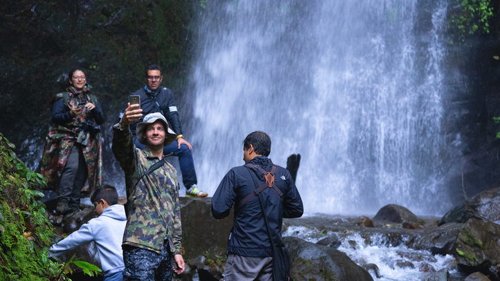
- Segment 2: You’ll pass by a key point of the route, La Naturaleza waterfall, visible in the distance on the left side of the trail. This is the largest waterfall in this area.
- Segment 3: You’ll see abandoned constructions, remnants of the area’s past use by illegal groups. However, the situation has changed, and the area is now safe.
- Segment 4: You’ll encounter the “Tree of Regret.” This imposing tree is known as the point where many adventurers decide not to continue the ascent due to its difficulty.
- Segment 5: You’ll reach the Hojas Forest, a beautiful area covered with dense vegetation—a good spot for a break.
- Segment 6: From the forest, the trail’s demand will intensify. The ascent is steeper than before, with small streams and stone-made stairs.
- Segment 7: You’ll find a small spring where you can drink clean water.
- Segment 8: The ascent continues, and the route becomes more challenging, including a section called “La Pared” where tree roots emerge, and you’ll need to use your hands to climb. There may be mud.
- Segment 9: You’ll notice you’re close to the summit as the vegetation starts to decrease in size. You’ll see more grass and ferns than trees. Finally, you’ll encounter mostly rocky terrain.
- Segment 10: You’ll have completed your ascent to the summit, offering an incredible panoramic view. From there, you can observe other mountains of the Farallones de Cali, take excellent photos, and breathe pure air.
The descent follows the same route.
This trail is vibrant with colors and filled with an impressive amount of fauna and flora. You’ll see a variety of birds, spiders, and butterflies.
Important
- Remember to ascend with a guide, and camping is not allowed.
- Price: There is a cost for entry to the trail.
- Schedule: Monday to Sunday, entry is from 6:00 am to 8:00 am, and exit by 4:00 pm.
Hiking towards the Attractive “Burbujas”
Difficulty Level: Moderate
The route is short, with a clearly marked trail.
One-way distance: Less than 1 km (0.6 miles)
One-way duration: 30 minutes
Climate: Humid tropical climate
The “Burbujas” pool is a deep part of the Pance River where you can swim. It features a small waterfall, creating movement and bubbles in the water.
To visit “Burbujas,” you must reach the El Pato sector in the Pance district. It’s a 1-hour drive from Cali, approximately 1 km (0.6 miles).
Once you pass the park entrance, you’ll need to walk a few minutes to reach the wooden bridge over the Pance River. The view is impressive.
Next, walk left on a trail parallel to the river until you find a yellow bridge. Cross it, and a few meters ahead, you’ll have arrived. It’s not a long route. Once at “Burbujas,” you can walk around the water source and explore the surrounding biodiversity.
You can swim and refresh; the water is very cold.
The return route is the same.
This trail is flat and surrounded by a lot of endemic vegetation.
Important
- Bring a change of clothes and sunscreen.
- There are many mosquitoes.
- The pool is deep, so be cautious if you can’t swim or if you’re with children.
- Schedule: Monday to Sunday, entry is from 6:00 am to 5:00 pm. I recommend going on weekdays.
Hiking in the Anchicayá Canyon
Difficulty Level: Medium
The descent is steep with stairs, and the trail is uncovered. There are areas where you must cross the Anchicayá River with the help of a rope or by boat.
One-way distance: 1 km (0.6 miles)
One-way duration: 2 hours
Climate: Humid tropical climate
To get to Anchicayá Canyon, drive 1 hour from Cali to the Quemeral district. Continue for another hour on an unpaved road to Km 81 Anchicayá Canyon. The Cortucan access point is there.
Public transport is an option.
The entrance is clear; you’ll receive a wristband and can park. Descend stairs to the Anchicayá River, where you’ll cross either by boat or using a rope. Crossing with the rope requires effort and swimming skills, and the boat service may be busy on weekends.
On the route, you’ll see 7 pools ranging from 8 cm to 13 meters (42 feet) in depth:
- La Bocana Pool
- El Baby Pool
- La Roca Pool
- Playa Rica Pool
- Tarzán Pool
- La Paila Pool
- El Guayacán Pool
The trail alongside the pools is uncovered and can get muddy; at times, you’ll need to cross them. Each pool has a lifebuoy indicating its depth, permissible sports, and the route to proceed.
The final two pools are the deepest, requiring crossing with a rope. El Guayacán Pool, with a depth of 8 meters (26 feet), allows diving.
You can return via the same trail.
Important
- Price: Entry to this park area and parking have a cost on weekends.
- Schedule: Monday to Sunday, stay from 7:00 am to 5:00 pm. On weekends, there is tourist guiding service, so you must pay insurance. I do not advise visiting on weekdays; it can be dangerous.
- Bring a change of clothes and a swimsuit.
Hiking in Cerro de Las 3 Cruces
Cerro de Las 3 Cruces is a famous hill with three cross-shaped monuments. Legend says a demon named Buziraco cursed the area, and to counteract it, priests built the crosses.
To reach the hill, go to Altos de Normandía, 4.2 km (2 miles) from Cali, a 20-minute drive with parking or public transport.
Difficulty Level: Medium
Trail Characteristics: Steep and slippery sections
One-way Distance: 2.2 km (1 mile)
One-way Duration: 1 hour
Altitude: Initial altitude of 1,018 meters (3,339 feet), ending at 1,072 meters (3,517 feet) above sea level
Climate: Tropical temperate
Normandía Trail
The ascent trail begins with a gradual incline on an unpaved path and progresses to a rocky section known as La Pared. This rocky area is steep and necessitates hands for climbing. Two paths emerge, opt for the right one.
Moving forward, you’ll enter the Frutas zone with grass and increased vegetation. The ascent continues, featuring stretches with mud and stones, particularly steep sections.
Upon reaching the summit, find a hydration point to rest and refresh. Afterward, climb some stairs to witness the impressive crosses.
For the descent, you can return through the same trail or choose the left path after La Pared.
Important
There are three trails to ascend Cerro de Las 3 Cruces:
- Granada Trail
- Chipichape Trail
- Normandía Trail (one of the most frequented)
Wear gripping footwear and consider going on weekdays, as weekends tend to be crowded.
Cost: There is an entrance fee.
Hiking Route in San Cipriano, Valle del Cauca
San Cipriano, a scenic village, is a 40-minute drive from Buenaventura, around 17 km (10 miles) away. Known for its natural beauty, the village uses motorcycles called “brujitas” on railway tracks for transportation.
Enjoy outdoor activities like tubing and hiking in San Cipriano.
Hiking in San Cipriano Natural Reserve
The San Cipriano Reserve protects the San Cipriano and Escalerete rivers and their surrounding forests on the Pacific coast.
It is a diverse ecosystem of tropical rainforests, ranked as the fourth wettest area globally.
The reserve features rich fauna and flora, including orchids, palms, spectacled bears, and guacharacos. Visitors can explore a butterfly garden, and camping is allowed
Refugio del Amor Trail
Difficulty Level: Medium
One-way Distance: 1 km (0.6 miles)
One-way Duration: 1 hour
Climate: Tropical humid
This trail is part of the main path in the San Cipriano Reserve, approximately 20 minutes from the village. It’s well-marked, taking you through small streams and waterfalls.
The first stop is Cascada Refugio del Amor, where you can swim and cool off. The journey can be tiring due to the temperature.
Descending stairs, you’ll encounter four more water sources, including small waterfalls, pools, and minor streams from the two main rivers. The fifth water source marks the end of the route.
The trail, clearly marked, showcases various plants and insects, including jumping frogs.
At the trail’s end, other routes await exploration, with water sources suitable for tubing.
Important
You can return through the same trail. However, there are other trails in this reserve that are worth exploring:
- Trail to Charco La Plateada
- Trail to Charco Los Sábalos
- Trail to Mariposario and Kiosco del Camarón Muchillá
This area is very humid, so bring light clothing and water-resistant footwear. Use bags or plastic protectors to cover your belongings if you enter the river.
Guided tours are available in the reserve.
- Cost: There is an entrance fee.
- Opening Hours: Monday to Friday from 8:00 am to 3:00 pm
- Website: https://cvc.gov.co/centro-educacion-ambiental-san-cirpiano
Climate in Valle del Cauca
The diverse geography of this department spans from the Pacific coast to the Andes mountains, resulting in a variety of climates based on altitude above sea level.
In Valle del Cauca, three main climates prevail:
- Tropical humid and semihumid (24°C to 30°C): Warm and humid, common in areas like Buenaventura at an altitude of 7 meters (22 feet) above sea level.
- Temperate tropical (17°C to 24°C): Intermediate climate, generally warmer than colder. Typical in Cali, at an altitude of 1,018 meters (3,339 feet) above sea level.
- Cold climate (below 10°C): Common in high-altitude areas with extreme climatic conditions, such as Punta Pance, the highest peak in the Farallones de Cali, at 4,100 meters (13,451 feet) above sea level.
Rainy Season in Valle del Cauca, Colombia
The region experiences rainfall ranging from 4,000 to 6,500 mm (0.157 to 255 inches) annually. However, in lower areas, rainfall is less than 2,000 mm (78 inches) per year.
The months of heaviest rainfall are April, May, October, and November. Consequently, the dry season typically occurs from December to March and from June to August, making it the best time for hiking.
Recommendations for Hiking in Valle del Cauca
To have a better experience, follow the rules of each location, usually established by government entities to preserve specific ecosystems. Common rules include:
- No littering.
- Avoid taking animals from their habitats.
- Do not cut or uproot plants.
- No smoking.
- No hunting.
- If not explicitly allowed, do not bring pets to protected areas.
- Avoid throwing anything into water sources.
- Refrain from making fires in unauthorized areas.
- Do not take shortcuts or walk in prohibited areas.
- Avoid consuming alcoholic beverages or psychoactive substances.
- Refrain from hiking in dangerous weather conditions.
- Do not camp where it is not allowed.
- Do not play music with speakers.
Additional tips to avoid complications:
- Plan your route in advance.
- Be cautious with online reservations, as they can sometimes be scams.
- Seek information on official government websites; it’s often available in English.
- Hire a reliable guide with a national tour guide card.
- If you have health issues, inform your companions.
- Foreigners should undertake these journeys in groups.
- Start your journey early in the morning to avoid the sun and high temperatures.
What to Bring for Hiking in Valle del Cauca
Hiking requires some preparation and gear. Here are some suggestions for what you could bring:
- A backpack
- A hiking pole
- Swimwear
- Floats for children if needed
- Comfortable and weather-appropriate clothing and footwear
- Identification documents
- Water and snacks
- A whistle
- A first aid kit
- Sunscreen and a hat
- Personal medications
- Change of clothes and shoes
- Local currency in cash.
More nature tourism experiences in Colombia
Here you will find a list of incredible destinations for hiking and other nature activities in Colombia:
- Best 9 Hiking Regions and 27 Routes in Colombia For Travelers
- Colombian Flowers: The Top 11 Most Representative Species
- Cocoa Guide Colombia – Features & Producers
More recommended hiking trails
- Discover the 7 Best Hiking Routes in Antioquia, Colombia
- The 9 Best Hiking Routes in Cundinamarca, Colombia
- Must-Try Hiking Trails in Magdalena, Colombia
- Discover 4 Must-Visit Hiking Trails in Amazonas, Colombia
- Explore 9 Scenic Trails in Eastern Plains, Colombia
- 5 Must-Experience Hiking Trails in Valle del Cauca, Colombia
- 6 Must-Experience Hiking Trails in Cauca, Colombia
- 5 Must-Experience Hiking Routes in Huila, Colombia
- The 6 Best Hiking Trails in Tolima, Colombia
- The 7 Most Incredible Hiking Routes in Boyacá, Colombia
- Hiking in Santander, Colombia – 5 Incredible Routes
- Hiking in Colombia’s Coffee Region: Top 5 Must-Visit Routes
