
Updated on 03/13/2024
Dear reader,
I would also like to recommend our Colombia travel guide, which provides a perfect overview of the tourist attractions in Colombia. Enjoy reading it!
If you’re a nature and adventure lover, this blog is perfect for you. You’ll find all the details about the hiking routes in Cundinamarca that you shouldn’t miss.
Content
Geographical Overview of Cundinamarca
Cundinamarca is one of Colombia’s 32 departments, situated in the Andean region and traversed by the Eastern Cordillera. It comprises 15 provinces and 116 municipalities, featuring the prominent Cerro de Majuy, which reaches an elevation of 3,700 meters (12,139 feet) above sea level.
Colombia is known for its three main mountain ranges: the Eastern, Central, and Western. Cundinamarca’s landscape offers various mountains, hills, and peaks ideal for hiking.
The department boasts over 212 protected areas, including sites, sanctuaries, and mountain trails. These areas provide information, directions, signage, and guided hikes led by local guides, some of whom speak English and French.
Hiking Routes in Cundinamarca
Next, I will give you the information of the 11 best routes in the different municipalities.
There will be popular routes and others less known.
This is the rubric that will explain the level of difficulty that will appear in each route.
Difficulty levels
Moderate
The terrain is flat, asphalted or paved and clearly marked. It is not very long and does not require excessive physical effort. Suitable for the whole family.
Medium
The terrain is mostly uncovered, there is unevenness, moisture and mud. The route requires significant physical effort and is not suitable for people with reduced mobility.
Difficult
The terrain is largely uncovered, there are steep climbs, uncertain weather conditions and high physical demands. The route is usually long and not suitable for the elderly, those with heart and respiratory diseases, children under 8 years old or pregnant women.
Hiking Routes in Bogotá, Cundinamarca
Bogotá is the capital of Colombia and the department, situated at an elevation of approximately 2,600 meters (8,500 feet) above sea level. It plays a central role in the country’s economy.
In Bogotá, you’ll find several hiking routes.
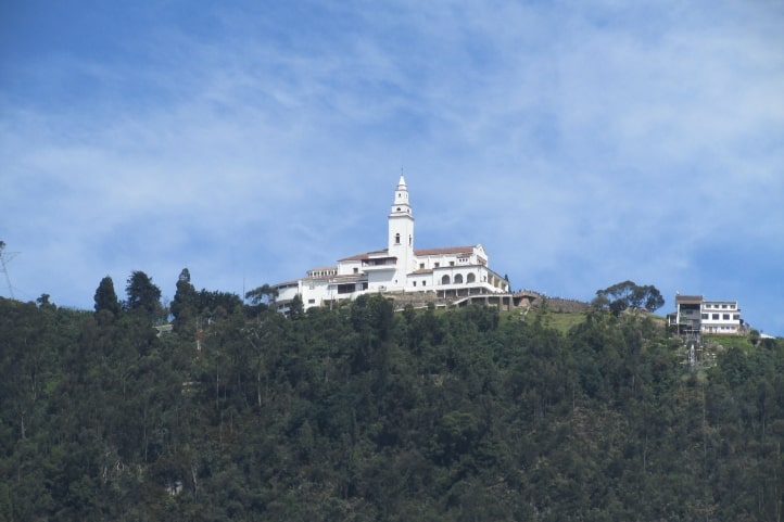
Ascent to Cerro de Monserrate
Difficulty level: Medium.
Distance to cover: 2,350 meters (7,700 feet), you’ll ascend nearly 450 meters (1,475 feet) in altitude and encounter 1,605 steps one way.
Duration: More than 1 hour and 30 minutes.
Altitude: Starts at 2,700 meters (8,860 feet) at the starting point and reaches 3,150 meters (10,350 feet) above sea level.
Climate: Cold.
This mountain, located to the east of the city, is probably the best-known hiking route in the capital. You can hike it on foot, by funicular, or by cable car, but I recommend the foot hike. At the top, you can visit the Basilica Santuario de Señor Caído de Monserrate, offering truly impressive views. While it demands some physical effort, the experience is well worth it. For a quieter visit, consider going on weekdays, as it can get crowded on weekends.
Opening Hours: Open every day. Monday to Friday from 5:30 am to 11:45 pm, Saturdays from 5:30 am to 4:00 pm, Sundays from 5:30 am to 6:00 pm, and holidays from 6:30 am to 6:00 pm.
Price: Pedestrian entry is free.
Website: https://monserrate.co/
Hiking on Sendero Santa Ana
Difficulty level: Medium.
Distance to cover: 1,750 meters (5,741 feet), which is about 3.2 km (1.9 miles) one way.
Duration: 3 hours.
Altitude: Starts at 2,625 meters (8,612 feet) at the starting point and reaches 3,035 meters (9,957 feet) above sea level.
Climate: Cold.
Santa Ana is a trail in the Usaquén locality, featuring points of interest like the ranger’s house, the Usaquén water tanks, and La Aguadora club.
The trail leads to a viewpoint with a northern view of Bogotá and offers diverse vegetation from the high Andean forest and subparamo ecosystem. You can also engage in activities like gymnastics, arborism, wildlife and flora documentation, and more.
Opening Hours: Thursdays to Fridays from 6:00 am to 11:00 am and Saturdays, Sundays, and holidays from 6:00 am to 12:00 pm.
Price: Free.
Website: https://www.acueducto.com.co/wps/portal/EAB2/Home/ambiente/senderos/santa_ana_la_aguadora
Quebrada La Vieja
Difficulty level: Medium.
Total Distance: 55 kilometers (34.1 miles).
Duration: 4 hours.
Altitude: Starts at 2,625 meters (8,612 feet) at the starting point and reaches 3,300 meters (10,827 feet) above sea level.
Climate: Cold.
The trail to Quebrada de La Vieja is located in the eastern forest of Bogotá in the Chapinero locality, with its entrance on Avenida Circunvalar.
You’ll encounter small waterfalls and enjoy a beautiful natural environment. There are species of 8 amphibians and 6 reptiles. Therefore, there are several ecological and cultural activities you can engage in.
There are four sections along the trail: Claro de la Luna, the closest; Mirador La Virgen; Alto de la Cruz; and Páramo Piedra Ballena, the most remote. You can explore all of them or choose specific sections based on your available time and physical condition.
Opening Hours: Tuesdays to Fridays from 6:00 am to 10:00 am and weekends, including holidays, from 6:00 am to 11:00 am.
Price: Free.
Website: https://www.acueducto.com.co/wps/portal/EAB2/Home/ambiente/senderos/quebrada_la_vieja
Hiking Routes in Chía, Cundinamarca
Chía, known as “the city of the moon,” is located north of Bogotá, surrounded by mountains that attract sports enthusiasts and tourists. It’s a great place for mountain biking and hiking, and some trails have interesting histories and myths. For example, there are records of human sacrifices to the goddess Chía in this area, and locals believe that the Mohán, a mythical figure, lives in the western mountain.
Hiking on Cerro de la Cruz de Lourdes
Difficulty level: Moderate.
Distance to cover: 2.4 km (1.4 miles) one way.
Duration: 30 minutes.
Altitude: Starts at 2,564 meters (8,409 feet) at the starting point and reaches 2,860 meters (9,383 feet) above sea level.
Climate: Temperate.
Hiking in the western hill of Chía starts at the entrance on the Tiquiza road and descends through El Boquerón. You can enjoy breathtaking views of the municipality and spot various bird species, including hummingbirds.
This site is also of religious significance, especially during Easter week, as believers symbolically commemorate the passion, death, and resurrection of Jesus Christ by gazing at a structure representing the cross where he was crucified.
Opening Hours: Open every day, 24 hours a day.
Price: Free.
Hiking to La Valvanera and El Mirador
Difficulty level: Moderate.
Distance to cover: 2.5 km (1.5 miles) one way.
Duration: 1 hour.
Altitude: Starts at 2,564 meters (8,409 feet) at the starting point and reaches 2,894 meters (9,495 feet) above sea level.
Climate: Temperate.
The Chapel of Our Lady of Valvanera is a colonial church that has had significant historical and religious influence on the residents of Chía and its surroundings since its construction in the early 20th century.
To reach it, you can climb a pedestrian path starting at the entrance in the Fonquetá hamlet. Alternatively, you can ascend the stairs, of which there are almost 200. During this journey, you can witness lush vegetation and breathe the purest air imaginable. Moreover, from the chapel’s viewpoint, you can admire the surroundings.
Opening Hours: The trail is open every day, 24 hours a day. However, the chapel only opens for mass on Saturdays and Sundays at 1:00 pm.
Price: Free.
Hiking Route in Choachí, Cundinamarca
Choachí, situated east of Bogotá, is a charming municipality renowned for its natural beauty and colonial-style architecture. Recognized by the World Tourism Organization as a top destination, Choachí features a picturesque urban area with colonial buildings and a central park.
Outdoor enthusiasts can enjoy activities like farming experiences and hiking, including a must-see journey to Colombia’s tallest waterfall.
Hiking at La Chorrera Adventure Park
Distance to cover: 5 km (3.1 miles) one way to the waterfall.
Duration: 2 hours.
Altitude: Starts at 1,924 meters (6,312 feet) at the starting point and ends at 2,554 meters (8,379 feet) above sea level at the waterfall.
Climate: Temperate and cold.
La Chorrera Adventure Park is home to Colombia’s tallest waterfall, La Chorrera, which stands at a remarkable height of 590 meters (1,935 feet). The trail to the waterfall winds through a lush Andean forest with native wildlife and flora, such as oaks, cedars, deer, and foxes. On weekends, there’s a guided system with stations every 300 meters (984.2 feet).
Please note that swimming at the waterfall is not allowed. The terrain can be rugged and wet, so wear comfortable, slip-resistant footwear. The waterfall’s water volume varies, and it’s best to visit between November and April.
If you bring your pet, keep them on a leash and, if necessary, use a muzzle.
The park offers activities like rappelling, ziplining, canopy tours, canyoning, birdwatching, and camping. You can also explore other natural attractions, including El Chiflón waterfall and the Cueva de los Monos (Monkey’s Cave).
Opening Hours: Open every day from 8:00 am to 6:00 pm.
Website: La Chorrera | Asociación de turismo la palma
Hiking Route in Sesquilé, Cundinamarca
Sesquilé is a Colombian municipality located at 2,595 meters (8,510 feet) above sea level in the northeast of the department of Cundinamarca. It’s a very popular tourist destination due to its colonial architecture and cobblestone streets. It’s a tranquil and welcoming town where you can enjoy its historical richness and a wide range of culinary offerings.
Sesquilé is also well-known for the Laguna de Guatavita, its main tourist attraction. This is a sacred lake for the Muisca people who inhabited the area.
Hiking at Laguna de Guatavita
Distance to cover: 1.2 km (0.74 miles) one way to the lake.
Duration: 2 hours.
Altitude: Starts at 2,559 meters (8,393 feet) at the starting point and ends at 3,100 meters (10,170 feet) above sea level at the lake.
Climate: Temperate and cold.
Laguna de Guatavita is closely associated with the Colombian municipality of Guatavita and was the religious capital of the Muisca people. It’s renowned as the place where the legend of El Dorado is believed to have originated. According to the legend, the Muisca people conducted a ritual in the lake to inaugurate their new leader, covering them with gold dust and submerging them along with treasures.
The lake’s surroundings cover 613 hectares and feature a nature-filled cobblestone trail alongside Embalse de Tominé. The trail has 6 stops, with a 200-meter (656.1 feet) walk between each one, leading to 3 viewpoints of the lake.
It’s advisable to carry cash as card payments might not have a reliable signal. Keep in mind that parking vehicles, camping, bringing food, and bringing pets are not allowed at this site.
Opening Hours: Tuesday to Sunday from 8:30 am to 4:00 pm.
Price: The park entrance fee has different costs for Colombians and foreigners.
Website: https://parques.car.gov.co/PaginaWeb/PaginaEstatica/Guatavita/QueHacer.aspx
Hiking Route in Arbeláez, Cundinamarca
Hiking on the Arbeláez – Fusagasugá Route
Distance to cover: 15 km (9.3 miles).
Duration: 3 hours and 30 minutes.
Altitude: 1,379 meters (4,524 feet) above sea level.
Arbeláez is a peaceful municipality in Cundinamarca, known for its lush vegetation and mild climate, making it a perfect destination for hiking. You can explore hiking routes within the town or venture towards Fusagasugá, the nearest city, which offers a wider range of amenities due to its larger population.
The hike from Arbeláez to the historic center of Fusagasugá is a memorable journey, where you’ll encounter trees, squirrels, and butterflies along the way. This area also offers opportunities for camping and mountain biking.
Opening Hours: Open every day, 24 hours a day.
Price: No cost.
Hiking Route in Cogua, Cundinamarca
Hiking at the Neusa Reservoir
Distance to cover: 6 km (3.7 miles).
Duration: 4 hours.
Altitude: 2,800 to 2,900 meters (9,186 feet) above sea level.
Climate: Cold.
This reservoir belongs to the municipalities of Cogua and Tausa and provides drinking water to Cogua and Zipaquirá. It also controls flooding in the Sabana de Bogotá and is, of course, a tourist site.
This 4,600-hectare paradise is located in the Eastern Andes, about 67 km (42 miles) from the Sabana de Bogotá. It offers areas for camping, fishing, and restaurants where you can try their typical dish, trout.
Hiking is a common activity here, typically covering all the park’s hectares. The site is beautiful due to its high Andean forest fauna and flora. You’ll see bellflowers, pink tunos, rabbits, owls, weasels, blackbirds, and many more.
Opening Hours: Tuesday to Sunday and holidays from 8:00 am to 4:00 pm, and for the camping area from 8:30 am to 10:00 pm.
Price: The park entrance fee has different costs for Colombians and foreigners.
Website: https://www.car.gov.co/saladeprensa/regresa-el-camping-al-parque-embalse-neusa
In conclusion, you can bring your pets with you on each of these routes, and guided tours in your preferred language are available through specialized guides.
Climate in Cundinamarca
Cundinamarca features different ecosystems, including moors, cloud forests, savannas, and wetlands, due to its geography. These diverse environments create various climatic conditions based on altitude above sea level, known as thermal floors.
In the department, three thermal floors prevail:
Cold Climate (5°C to 15°C): This temperature characterizes mountainous areas with high altitudes, such as the Sumapaz Moor.
Temperate Climate (10°C to 20°C): This is an intermediate and cool climate with seasons of heavy rains, much like Bogotá.
Warm Climate (25°C to 30°C): This is a hot and dry temperature found in low-lying areas like Girardot.
Recommendations for Hiking in Cundinamarca
To have the best experience, always adhere to the rules of each location. These are typically stipulated by governmental entities to preserve specific ecosystems. The most common rules include:
- Not leaving litter behind.
- Not removing animals from their habitats.
- No smoking.
- Avoid making fires in unauthorized areas.
- Not consuming alcoholic beverages or psychoactive substances.
- Not playing loud music.
To avoid complications, consider the following tips:
- Be cautious with online reservations; some may be scams.
- Always look for information on official government websites, where you can find information in English.
- Hire a reliable guide with a national tourist guide card.
- If you have health issues, inform your companions.
- Foreigners should undertake these routes in a group.
- Start your journey early in the morning to avoid the sun and extreme temperatures.
What to Bring for Hiking in Cundinamarca
Hiking requires some preparation and equipment. Here are some suggestions for what to bring:
- A backpack.
- Comfortable and weather-appropriate clothing and footwear.
- Identification documents.
- Water and snacks.
- A first aid kit.
- Sunscreen and a hat.
- Personal medications.
- Spare clothing and footwear.
- Local cash.
These items are essential for your health and safety during hikes. Contact us, and we’ll be more than happy to assist you with your next adventure. Don’t miss the wonders that Colombia has to offer! Until next time, traveler!
More nature tourism experiences in Colombia
Here you will find a list of incredible destinations for hiking and other nature activities in Colombia:
- Best 9 Hiking Regions and 27 Routes in Colombia For Travelers
- Colombian Flowers: The Top 11 Most Representative Species
- Cocoa Guide Colombia – Features & Producers
More recommended hiking trails
- Discover the 7 Best Hiking Routes in Antioquia, Colombia
- The 7 Most Incredible Hiking Routes in Boyacá, Colombia
- The 9 Best Hiking Routes in Cundinamarca, Colombia
- Hiking in Santander, Colombia – 5 Incredible Routes
- How to Hike the Lengerke Trail in Colombia: A Complete Guide
- Hiking in Colombia’s Coffee Region: Top 5 Must-Visit Routes
- Must-Try Hiking Trails in Magdalena, Colombia
- Discover 4 Must-Visit Hiking Trails in Amazonas, Colombia
- The 6 Best Hiking Trails in Tolima, Colombia
- Climbing Tolima Volcano: A Challenging Andes Adventure
- 5 Must-Experience Hiking Routes in Huila, Colombia
- 5 Must-Experience Hiking Trails in Valle del Cauca, Colombia
- 6 Must-Experience Hiking Trails in Cauca, Colombia
- Explore 9 Scenic Trails in Eastern Plains, Colombia
- Hiking in Colombia: Checklist of 23 Essential Items to Bring
- The 9 Wild and Adventurous Hiking Routes in the Colombian Andes
- 9 Hiking Routes in Colombia Ideal for Families
