
Updated on 03/13/2024
Dear reader,
I would also like to recommend our Colombia travel guide, which provides a perfect overview of the tourist attractions in Colombia. Enjoy reading it!
If you are a hiking and nature enthusiast, this blog is the right one for you. Here I present to you the 7 most outstanding trails in the Antioquia department.
Content
Geographic Overview in Antioquia, Colombia
Antioquia is a Colombian department in the northeastern corner. It has 125 municipalities grouped into 9 subregions, with Medellín as the capital. It’s known for its cultural and natural wealth, featuring diverse landscapes, including flat and mountainous areas, canyons, rivers, basins, and lagoons.
One notable place is the Páramo del Sol or Frontino, the highest peak in the department, standing at around 13,385 feet above sea level.
Hiking Routes in Antioquia, Colombia
Next, I will provide you with information on the 7 best trails in various destinations of Antioquia, Colombia. There are popular routes as well as lesser-known ones. Here is the marking that explains the difficulty level of each route.
Difficulty levels
Moderate
The terrain is flat, asphalted or paved and clearly marked. It is not very long and does not require excessive physical effort. Suitable for the whole family.
Medium
The terrain is mostly uncovered, there is unevenness, moisture and mud. The route requires significant physical effort and is not suitable for people with reduced mobility.
Difficult
The terrain is largely uncovered, there are steep climbs, uncertain weather conditions and high physical demands. The route is usually long and not suitable for the elderly, those with heart and respiratory diseases, children under 8 years old or pregnant women.
Hiking Routes in Jardín, Antioquia
Jardín is a picturesque town known for its beautiful colonial architecture and colorful streets. It’s a tourist destination that attracts visitors and hikers from around the world. It covers an area of 86.5 mi².
Here, you can explore:
Hiking in the Natural Reserve Cueva del Esplendor
Difficulty Level: Difficult
Distance to cover: 3 mi one-way
Duration: 3 hours one way
Altitude: Start point at 5,741 ft, finishing at 7,545 ft above sea level.
Climate: Temperate
In this reserve, there’s an amazing cave in the Cuchilla-Jardín-Támesis area with a waterfall flowing from the cave’s ceiling, creating a stunning sight.
You can reach it by walking from Jardín to the Reserve entrance. Many use a local vehicle called a Willys, but the hike is worth it.
Inside the Reserve, you can hike to the cave from Alto de las Flores, a 3-mile walk through a native forest with local wildlife and flora, including oaks and butterflies.
Opening Hours: Tuesday to Friday from 9:00 am to 6:00 pm, and weekends from 7:00 am to 6:00 pm.
Website: https://jardin.antioquia.in/Sitios-Turisticos/reservas-naturales/reserva-natural-cueva-del-esplendor
Hiking Routes in Medellín, Antioquia
Medellín, the capital of Antioquia, is known as “the city of eternal spring” for its pleasant climate. It’s a central hub for economics, politics, and tourism in Colombia, located at an altitude of 4,095 feet above sea level and covering an area of 380,146.74 square miles. Medellín offers diverse activities, from dancing to exploring nature at various destinations.
Hiking at the Joaquín Antonio Uribe Botanical Garden
Difficulty Level: Moderate
Distance to cover: Approximately 2.5 mi for the complete route
Duration: 1 hour and 30 minutes
Altitude: 4,095 ft above sea level
Climate: Temperate
The Medellín Botanical Garden, in the Aranjuez commune, is a must-visit. It covers 14 hectares with diverse flora and fauna, including orchids, native trees, and a butterfly garden.
You can explore the trails, including the full route through 5 learning spaces: Butterfly House Forjas Bolívar, Prehistoric Plants Trail Álvaro Cogollo Pacheco, Urban Agriculture Laboratory, Reading and Culture Room, and Documentation Center. Just arrive on time at the Grandfather Tree to enjoy it.
Note that only service animals with proper documentation are allowed, and guided tours in English are available if desired.
Opening Hours: Monday to Friday from 9:00 a.m. to 5:00 p.m. and on weekends and holidays from 10:00 a.m. to 4:00 p.m.
Guided Tours: Tuesdays at 11:00 a.m., Thursdays at 2:00 p.m., Saturdays at 11:00 a.m., and Saturdays at 2:00 p.m.
Website: https://www.botanicomedellin.org/
Cerro Pan de Azúcar
Difficulty Level: Moderate
Distance to cover: 1.4 mi one way on its main trail.
Duration: 1 hour and 30 minutes
Altitude: 4,095 ft at the starting point, reaching 7,014 ft above sea level.
Climate: Cold
This hill, located in the Villa Hermosa commune of central-eastern Medellín, is historically, archaeologically, and touristically significant. It houses over 175 plant species, including pines, and more than 134 animal species like opossums, squirrels, and foxes. There have been 159 archaeological findings in the area.
The hill offers various hiking routes and is suitable for mountain biking, with two main routes: the 5.9-mile “Camino de la Vida” (Path of Life) and the popular circular “Ruta de Campeones” (Champions’ Route).
As you follow these routes, you’ll encounter 7 eco parks (Golondrinas, Trece de Noviembre, La Cima, Las Tinajas, La Castro, Villa Turbay, and Campos). Before reaching the summit, you’ll pass through the El Faro neighborhood, and from the top, you’ll enjoy panoramic views of the city and part of the Aburrá Valley.
You’ll also find 24 hectares of fique, a natural fiber plant, and 8 agroecological gardens along the way.
Opening Hours: Every day from 6:00 a.m. to 6:00 p.m.
Website: https://www.medellin.gov.co/es/secretaria-medio-ambiente/medellin-biodiversa/cerro-pan-de-azucar/
Hiking in Parque Arví
Difficulty Level: Intermediate
Distance to cover: 0.9 mi one way on the Sendero La Flora, but if you were to explore the entire park, it would be 11.1 mi.
Duration: 1 hour on Sendero La Flora. 7 hours and 30 minutes to cover the entire park.
Altitude: 4,095 ft above sea level.
Climate: Temperate
Parque Arví, situated in the Santa Helena district, covers 1,761 hectares of native forest. It’s a popular tourist destination where you can enjoy activities such as hiking on its many trails, night walks, birdwatching, cycling, and picnics. You can also explore the park’s history and its diverse wildlife and plant life.
Among its trails is the “Sendero La Flora,” one of the most visited trails, which consists of 3 sections: La Rojas, La Gutiérrez, and La Cuchilla. Other trails include:
- Sendero Ancestral
- Sendero Camino de la Cuesta
- Sendero Conector El Tambo
- Sendero El Arroyuelo
- Sendero Zango
- Sendero Portón del Guayabo
- Sendero Arrierías
- Sendero Embrujado
- Sendero El Molino
- Sendero Conector La Laguna – Mazo
You can explore some of these trails or complete the entire circuit, as they are interconnected. These routes stretch across municipalities in Antioquia, including Medellín, Bello, Copacabana, and Guarne.
Feel free to bring your pet along, but remember to ensure their safety with a collar or leash, as required.
Opening Hours: Tuesday to Sunday from 9:00 am to 6:00 pm.
Website: Parque Arví (parquearvi.org)
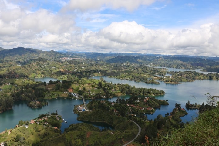
Hiking Routes in Guatapé, Antioquia
Guatapé is a picturesque Colombian town covering 28.57 square miles, known for its colorful houses and stunning reservoir. It offers beautiful natural scenery, Antioquian culture, and typical dishes. It’s located at an altitude of 6,316 feet above sea level.
Hiking in Peñón and Guatapé Reservoir
Difficulty Level: Intermediate
Distance to cover: 8 mi one way on the common adjacent route.
Duration: 4 hours
Altitude: 6,316 ft above sea level, and you will ascend by 787.4 ft.
Climate: Temperate and cold.
Peñón de Guatapé, or Piedra del Peñol, is a 721.7-foot monolith in Guatapé, composed of quartz, feldspar, and mica. To reach the summit, climb 740 steps for a panoramic view of the 2,200-hectare Guatapé Reservoir.
The reservoir offers water sports, boat trips, and jet skiing, and sport fishing is popular. Hiking enthusiasts can explore various routes. While many drive to the area due to its distance, walking lets you experience the local culture.
The hike often begins at Piedra del Peñol, passing the Convent of the Benedictine Nuns and the Benedictine Monastery before reaching the reservoir. You can also explore nearby Antioquian trails like Vereda Miraflores, Vereda Santa Rita, Vereda Magdalena, Vereda Chapa, and Vereda Guatimito.
Opening Hours: Daily from 8:00 a.m. to 6:00 p.m.
Website: https://www.guatapecolombia.net/portfolio/penon-de-guatape/
Hiking Routes in Envigado, Antioquia
Envigado is a Colombian municipality situated at an altitude of 5,495 feet above sea level. It provides a memorable experience with vibrant nighttime illuminations and a variety of ecological activities, including hiking, across its 30.12 square miles of area.
Hiking in Reserva San Sebastián
Difficulty Level: Intermediate
Distance to cover: 6.8 mi one way throughout the reserve.
Duration: 6 hours
Altitude: 5,495 ft at the starting point, and you’ll finish between 8.99 to 9.67 ft above sea level, depending on the trail you choose.
Climate: Cold
The San Sebastián Reserve, in El Retiro, Colombia, covers over 200 hectares of lush cloud forest with moss, ferns, orchids, and native flora.
It’s an excellent place for hiking and spiritual reflection. The recommended route starts at the “Portón de las Flores” trail, leading to viewpoints like “Mirador de los Valles,” “Mirador del Nevado del Volcán Nevado de Ruiz,” and “Mirador de los Caminantes.” On clear days, you can see the Aburrá Valley and Nevado del Ruiz Volcano.
Afterward, take the “Ruta del padre Calixto” (Father Calixto’s Route) to descend to the Normandía district, covering about 1.25 miles deeper into the native forest.
Many use this reserve as a starting point for other routes to places like Cascada Chorro Golondrinas, Cuevas del Higuerón, Vereda El Salado, and more.
Hiking Routes in Urrao, Antioquia
Urrao, a scenic Colombian municipality spanning 446.7 square miles, is surrounded by a breathtaking mountainous landscape. It is renowned for its ecotourism and offers opportunities for archaeological, ethnic, and cultural tourism. The town is situated at an altitude of 5,770 feet above sea level.
Hiking in Páramo del Sol
Difficulty Level: Difficult
Distance to cover: 10 mi
Duration: 4 days in total
Altitude: 5,770 ft at the starting point, and you’ll finish at 13,085 ft above sea level, depending on the trail you choose.
Climate: Cold
Páramo del Sol, also known as Frontino Páramo, spans 11.58 square miles and is rich in flora, fauna, and water sources. Walking through this area, you might spot a spectacled bear and enjoy the fragrance of páramo pine, not to mention the impressive Frailejones.
Climbing it through either the El 14 or Proaves routes takes several days due to the distances and weather conditions. You can camp in your own tent or find rural houses offering this service.
Here’s a simplified itinerary for the Proaves route:
- Day 1: Arrive in Urrao, set your accommodation, and check your equipment.
- Day 2: Ascend through several key points, starting with Vereda El Chuscal, followed by Sendero Proaves, where you can visit the Proaves Colibrí del Sol Reserve and encounter the critically endangered Colibrí del Sol. You will also see the Piedra del Oso (Bear’s Rock).
- Day 3: Climb to Alto de la Campana and the lagoon, enjoying the views of Alto del Burro and La Cumbre. Then, head to the base camp.
- Day 4: Descend from the base camp, continue to the El 14 route, and finally reach Vereda El Chuscal.
This trek requires significant physical fitness, so it’s important to train and acclimatize beforehand. The best time to visit is from January to March when the weather is dry.
For safety, you must go with an experienced guide. Guides who speak English and French are available in the area.
Due to the weather, bring warm clothing, food for four days, and insulated tents. If you have heart or respiratory issues or are pregnant, it’s advisable to avoid this trek. Pets are not allowed.
Opening Hours: Every day, 24 hours a day.
Climate in Antioquia, Colombia
The climate in this Colombian department is quite varied due to factors such as altitude, topography, winds, and others.
In the department, three main climate zones prevail:
- Warm and semi-humid climate (26°C to 32°C or 79°F to 90°F): This climate features high temperatures and consistent rainfall, as found in places like Caucasia, Antioquia.
- Temperate climate (16°C to 25°C or 61°F to 77°F): This tends to be more warm than cold. It’s common in areas like Caldas, Antioquia.
- Cold climate (8°C to 15°C or 46°F to 59°F): In this climate, temperatures are typically cold and accompanied by winds, as experienced in places like Jardín, Antioquia.
Of course, temperatures can vary based on altitude and the time of year, but this provides a rough estimate.
Recommendations for Hiking in Antioquia
To have the best hiking experience, please note the rules of the respective hiking areas.
- Do not leave trash.
- Do not disturb animals in their habitats.
- Avoid smoking or consuming alcoholic beverages or drugs.
- Do not take pets into protected areas.
- Respect water sources and avoid open fires..
- Do not play music on loudspeakers.
Additionally, to avoid any hassles, consider the following tips:
- Be cautious with online reservations, as some may be scams.
- Seek information from official and government websites, where you can often find content in English.
- Hire a trustworthy guide with national tour guide accreditation.
- If you have health issues, inform your hiking companions.
- Foreigners should consider hiking in groups.
- Begin your hike early in the morning to avoid strong sun and high temperatures.
What to Bring for Hiking in Antioquia
Hiking requires some preparations and gear. Here are some suggestions for what you should bring:
- Backpack.
- Comfortable and weather-appropriate clothing and footwear.
- Identity documents.
- Water and snacks.
- First aid kit.
- Sunscreen and a cap.
- Personal medications.
- Spare clothing and footwear.
- Local currency in cash.
More nature tourism experiences in Colombia
Here you will find a list of incredible destinations for hiking and other nature activities in Colombia:
- Best 9 Hiking Regions and 27 Routes in Colombia For Travelers
- Colombian Flowers: The Top 11 Most Representative Species
- Cocoa Guide Colombia – Features & Producers
More recommended hiking trails
- Discover the 7 Best Hiking Routes in Antioquia, Colombia
- The 7 Most Incredible Hiking Routes in Boyacá, Colombia
- The 9 Best Hiking Routes in Cundinamarca, Colombia
- Hiking in Santander, Colombia – 5 Incredible Routes
- How to Hike the Lengerke Trail in Colombia: A Complete Guide
- Hiking in Colombia’s Coffee Region: Top 5 Must-Visit Routes
- Must-Try Hiking Trails in Magdalena, Colombia
- Discover 4 Must-Visit Hiking Trails in Amazonas, Colombia
- The 6 Best Hiking Trails in Tolima, Colombia
- Climbing Tolima Volcano: A Challenging Andes Adventure
- 5 Must-Experience Hiking Routes in Huila, Colombia
- 5 Must-Experience Hiking Trails in Valle del Cauca, Colombia
- 6 Must-Experience Hiking Trails in Cauca, Colombia
- Explore 9 Scenic Trails in Eastern Plains, Colombia
- Hiking in Colombia: Checklist of 23 Essential Items to Bring
- The 9 Wild and Adventurous Hiking Routes in the Colombian Andes
- 9 Hiking Routes in Colombia Ideal for Families
