
Updated on 04/03/2024
Dear reader,
I would also like to recommend our Colombia travel guide, which provides a perfect overview of the tourist attractions in Colombia. Enjoy reading it!
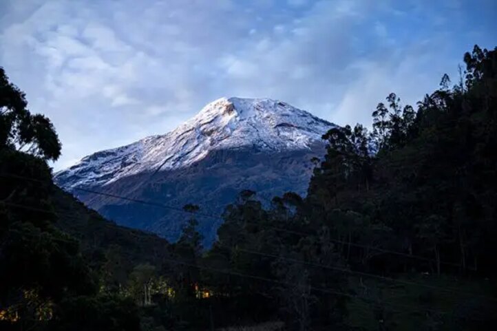
Have you ever dreamed of climbing a volcano? Not just any volcano, but one that is shaped like a perfect cone, covered with snow and ice, and surrounded by stunning landscapes? If so, then you might want to consider Tolima Volcano, one of the most impressive and challenging peaks in Colombia.
Content
Introduction Tolima Glacier and Volcano
Nevado del Tolima is 5,225 meters (17,126 feet) above sea level. The department of Tolima hosts the volcano and different sides offer access to it. The tour from Salento usually takes 4 days. Climbing during the dry season is always advisable. The best months are December to March.
You should be in good physical condition, but no previous experience is necessary. However, the glacier is filled with crampons. This requires appropriate footwear. The rest of the hike should be done with rubber boots.
Donkeys carry the large luggage, so you can keep the backpack small and light.
Departure from Salento Quindio to the 1st stage
Altitude Salento: 1,895 meters (6,217 feet) above sea
Level Altitude Cocora Valley: 2,400 meters (7,875 feet) above sea level
Height of mountain hut: 3,700 meters (12,142 feet) above sea level
Total distance: 18 kilometers (11.25 miles)
Highest point: 3,700 meters (12,142 feet) above sea
Level Altitude uphill: 1,800 meters (5,905 feet) in
Altitude downhill: –
Salento is known as the most touristic place in the whole coffee zone of Colombia. From there there are many offers for various hikes and climbs, including the spectacular Tolima Volcano, one of the highest and most active volcanoes in the country. There are several providers, whereby the mountain guides are mostly freelance and work for different companies.
However, one should be careful to choose providers with small group sizes. There should also be a technical briefing where the material is checked.
You can usually organize missing material at short notice, unless you have shoe size 46 or larger.
On the first day we leave very early with a transport from Salento to the Cocora Valley. From there, the first stage to the mountain hut starts on foot. Depending on the month and the weather, the route can be very muddy. However, the path is easy and requires no technical skills. Even so, you cover a few meters of altitude on the first day. You should therefore reduce the weight to a minimum.
Shortly after arriving at the hut, I got sick from the altitude and had to vomit twice. After a short siesta, however, I felt better again.
The dormitories in the huts are very rudimentary and equipped with scratchy woolen blankets. I had a silk sleeping bag with me, which was very comfortable. However, it can get very cold at night. I recommend thermal underwear as a pijama here.
The best beds are downstairs, but not next to the front door.
The food in the huts is very good.
Start from the mountain hut to the 2nd stage
Height mountain hut: 3,700 meters (12,142 feet) above sea
Level Base camp altitude: 4,600 meters (15,000 feet) above sea level
Total distance: 9 kilometers (6 miles)
Highest point: 4,600 meters (15,091 feet) above sea
Level Altitude uphill: 900 meters (2,952 feet)
Of altitude downhill: –
The second day starts relaxed and the group does not have to start before 08:00. Depending on the weather, the guides can make a detour to the lagoon. The distance and the altitude to be climbed are relaxed. Don’t forget, however, you are already at over 3,700 (12,142 feet) meters above sea level. One should therefore divide one’s strength.
Reaching the camp in the early afternoon is normal, but setting it up requires teamwork. Good and warm equipment is essential, because the provided tents and sleeping bags are not necessarily suitable for high alpine terrain. In addition to the cold, the wind is particularly unpleasant.
The guides will cook. More or less professional depending on the company.
I didn’t get sick again at base camp, but I suffered from lack of energy and couldn’t eat.
Here, too, material is transported with pack donkeys.
Start from the base camp to the 3rd stage
Altitude base camp: 4,600 meters (15,091 feet) above sea level
Height Tolima peak: 5.225 meters (17,142 feet) above sea level
Total distance: 12 kilometers (7.5 miles)
Highest point: 5.225 meters (17,142 feet) above sea level Meters
Uphill: 625 meters (2,050 feet)
Of altitude difference downhill: 1,500 meters (4,921 feet)
The king’s stage of the Tolima Volcano climb starts at 01:00 in the morning. Many of the participants are already in their sleeping bags with all their equipment so that it can go faster. I had everything on because my sleeping bag didn’t offer any protection against the cold.
With the headlamp and the mountain boots, we then head towards the summit. Above all, mental strength is required here, as the wind can blow quite a bit around your ears. However, I was not there because my oxygen saturation values were too low and I did not feel well either. Of 8 participants in the group, 3 stayed behind at the camp.
As soon as the glacier begins, the crampons are fitted. You are then on the summit before sunrise and with a bit of luck with the weather, you can take the best photos of your life.
Then it’s back to the camp to relax and have breakfast.
Later it goes from the camp back to the hut. The rest of the day is to relax.
Start from the mountain hut to the 4th stage
Altitude Salento: 1,895 meters (6,217 feet) above sea
Level Altitude Cocora Valley: 2,400 meters (7, 874 feet) above sea level
Height of mountain hut: 3,700 meters (12,139 feet) above sea level
Total distance: 18 kilometers (11.25 miles)
Highest point: 3,700 meters (12,139 feet) above sea
Level Altitude uphill: – Ft
Downhill: 1,800 meters (5,905 feet)
On the 4th day and the last stage, after an early breakfast, we return to the Cocora Valley. You walk back the same way. This stage is relaxed as it is mostly downhill.
Arriving in the Cocora Valley, a transport to Salento awaits. We were back around 2pm and had lunch together.
Recommended packing list for Nevado del Tolima:
- Underpants (Anything over 1 is Luxury)
- Socks (1 pair for each day in wet weather)
- Pants (water-repellent is recommended but not necessary)
- Sweater, Gillet, etc. (warm top)
- Windbreaker (should be water repellent)
- Balaclava
- Cap
- Gloves
- Rubber boots (can also be rented on site)
- Hiking shoes (must be suitable for crampons)
- Headlamp
- Thermal underwear (recommended for summit climbs)
- Warm pajamas
- Walking sticks
- Sunglasses
- Sun cream
- Hat
- Toothbrush and toothpaste
- Small towel (in the hut you can take a warm shower)
- Inlet sleeping bag (silk sleeping bag)
- Drinking bottle
- Rain gear or rain poncho
- Battery (there is electricity in the hut, but difficult with many guests)
- Sleeping bag (can be rented)
- Sleeping mat (can be rented)
- Tent (Can be rented)
Conclusions Nevado del Tolima
First of all, when I almost climbed Tolima Volcano, we had a very homogenous group with similar performance levels, which gave the group a good dynamic. We were also incredibly lucky with the weather and had perfect conditions. Although our starting position was perfect and I am personally in good physical condition, the altitude can put a spanner in the works for any participant. Don’t underestimate the height. You should definitely be aware of the dangers of altitude sickness and not take any risks.
The hike to Nevado del Tolima is incredibly beautiful and you also go through different zones. One sees wax palms, forest, paramo and steppe.
I can absolutely recommend this hike and maybe we’ll see each other too, because I still have an open score with the summit.
More nature tourism experiences in Colombia
Here you will find a list of incredible destinations for hiking and other nature activities in Colombia:
- Best 9 Hiking Regions and 27 Routes in Colombia For Travelers
- Colombian Flowers: The Top 11 Most Representative Species
- Cocoa Guide Colombia – Features & Producers
More recommended hiking trails
- Discover the 7 Best Hiking Routes in Antioquia, Colombia
- The 7 Most Incredible Hiking Routes in Boyacá, Colombia
- The 9 Best Hiking Routes in Cundinamarca, Colombia
- Hiking in Santander, Colombia – 5 Incredible Routes
- How to Hike the Lengerke Trail in Colombia: A Complete Guide
- Hiking in Colombia’s Coffee Region: Top 5 Must-Visit Routes
- Must-Try Hiking Trails in Magdalena, Colombia
- Discover 4 Must-Visit Hiking Trails in Amazonas, Colombia
- The 6 Best Hiking Trails in Tolima, Colombia
- Climbing Tolima Volcano: A Challenging Andes Adventure
- 5 Must-Experience Hiking Routes in Huila, Colombia
- 5 Must-Experience Hiking Trails in Valle del Cauca, Colombia
- 6 Must-Experience Hiking Trails in Cauca, Colombia
- Explore 9 Scenic Trails in Eastern Plains, Colombia
- Hiking in Colombia: Checklist of 23 Essential Items to Bring
- The 9 Wild and Adventurous Hiking Routes in the Colombian Andes
- 9 Hiking Routes in Colombia Ideal for Families
