
Updated on 03/13/2024
Dear reader,
I would also like to recommend our Colombia travel guide, which provides a perfect overview of the tourist attractions in Colombia. Enjoy reading it!
If you are a nature and hiking enthusiast, this blog is right for you. I will present to you the 7 most outstanding trails in Boyacá that will allow you to immerse yourself in the culture and beauty of this Colombian department.
Content
Geographical Overview in Boyacá
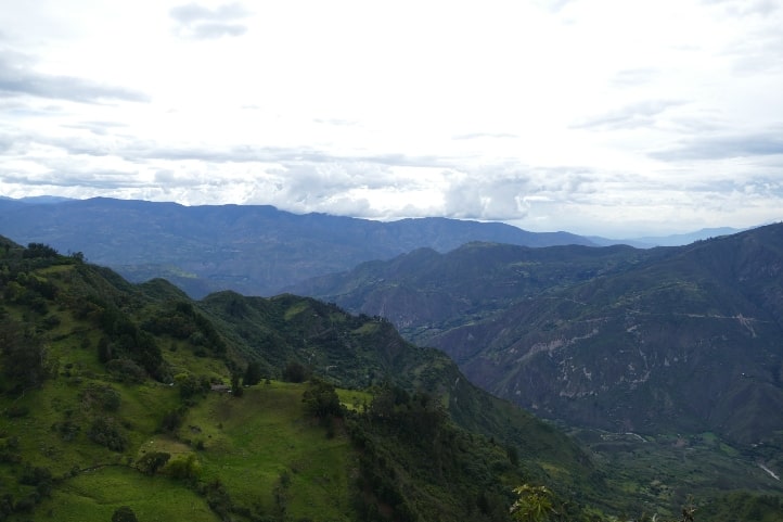
Boyacá, one of Colombia’s 32 departments, has Tunja as its capital and consists of 123 municipalities grouped into 12 provinces. Located in the Andean region in the central-east of the country, Boyacá is intersected by the Eastern Cordillera.
This Colombian department boasts diverse geography, featuring both mountainous and flat regions. Its terrain includes mountains, hills, plains, plateaus, and valleys.
Notably, the Saboyá Moor stands out, reaching an altitude of 13,123 feet above sea level. Here, you’ll find water sources and a unique species of frailejón, a plant crucial to the ecosystem, but currently facing threats.
Hiking in Boyacá
Hiking in Boyacá is a highly favored activity among both locals and tourists. Since 2018, the Government of Boyacá has launched the “Walk through Boyacá” project, aimed at promoting exploration of various trails in the region.
This hiking destination is cherished for its breathtaking landscapes, abundant historical routes, 4 natural parks, and 47 ecological reserves.
Boyacá offers a paradise for nature enthusiasts, with opportunities for cultural immersion, bird watching, plant observation, and much more. What’s more, these areas provide comprehensive information, clear directions, and signage, along with guided tours led by local experts who can communicate in languages like English and French.
Hiking Routes in Boyacá
Next, I will provide you with information on the 7 most incredible hiking routes in the various municipalities of Boyacá, Colombia. There will be popular routes and others less known. This is the key that will explain the level of difficulty that will be indicated in each route.
Difficulty levels
Moderate
The terrain is flat, asphalted or paved and clearly marked. It is not very long and does not require excessive physical effort. Suitable for the whole family.
Medium
The terrain is mostly uncovered, there is unevenness, moisture and mud. The route requires significant physical effort and is not suitable for people with reduced mobility.
Difficult
The terrain is largely uncovered, there are steep climbs, uncertain weather conditions and high physical demands. The route is usually long and not suitable for the elderly, those with heart and respiratory diseases, children under 8 years old or pregnant women.
Hiking Routes in Villa de Leyva, Boyacá
Villa de Leyva is a famous and charming colonial town, known for its enormous tourist appeal and architectural beauty. It is located at an elevation of 7,020 feet above sea level (fasl).
Among its many ecological and cultural activities, hiking is one of them. These are some of the routes you should explore.
Hiking to the Blue Pools
Difficulty level: Moderate.
Distance to cover: 1.09 miles one way.
Duration: 30 minutes.
Altitude: 7,020 fasl
Climate: Dry.
Located 1.86 miles from the urban center of Villa de Leyva, this trail will take you through a desert-like natural landscape where you’ll observe the impressive Blue Pools, small artificial lakes that, due to the high concentrations of sulfur, selenium, and copper in the surrounding soil, take on that hue.
Additionally, you can go horseback riding, bring your pet, enjoy bird watching, or simply relax in the serenity that the environment offers.
Hours: Open every day from 8:00 am to 5:00 pm.
Website: https://pozosazules.com.co/
Hiking in the Iguaque Fauna and Flora Sanctuary
Difficulty level: Medium.
Distance to cover: 2.9 miles one way.
Duration: 3 hours.
Altitude: Starts at 9,317 fasl and ends at 11.97 fasl.
Climate: Mountainous and dry.
This reserve spans Villa de Leyva, Arcabuco, and Chíquiza municipalities, with a Villa de Leyva entrance approximately 9.32 miles from the town center.
It covers 6,750 hectares of Andean forest and páramo, showcasing diverse biodiversity. Explore iconic Colombian species, including orchids and frailejones, and encounter wildlife like foxes, opossums, larks, and hummingbirds.
Activities include hiking the famous Bachué Trail to the Sacred Laguna de Iguaque, steeped in Muisca legend.
Visit during the dry season (January to March), with daily visitor limits (138 people) and accommodations for 98.
For safety, avoid the trail if pregnant, have heart/respiratory issues, or travel with children under 8.
Please note that pets are not permitted in this area, and activities such as tree-cutting or littering in the lagoon are strictly prohibited.
Hours: The sanctuary is open every day from 8:00 am to 5:00 pm, and the Bachué Trail is open from 8:00 am to 10:00 am.
Website: https://www.parquesnacionales.gov.co/nuestros-parques/sff-iguaque/#ecoturismo
Hiking Routes in Monguí, Boyacá
Monguí is a picturesque Colombian municipality that offers many opportunities for hiking and exploring ecosystems. It is located at an elevation of around 9,514 feet above sea level. There are several fantastic sites to explore, and the following is one of the best.
Ascent to the Ocetá Páramo
Difficulty level: Difficult.
Distance to cover: 8.69 miles one way.
Duration: Over 4 hours.
Altitude: Starts at 9,514 fasl and ends at 12.79 fasl.
Climate: Cold mountain.
Known as the world’s most beautiful páramo, this place is a majestic hub of biodiversity, featuring frailejones, hops, rabbits, amphibians, deer, and Colombia’s national symbol, the condor.
The Black Lagoon, situated atop its central peak, and the Stone City, resembling alleys due to fallen stones, add to its allure.
Most treks lead to the 239.01 feet-long Black Lagoon, but there’s no lodging or camping, and temperatures plummet at night, so begin your hike early and dress warmly with hats and gloves.
Leave your pets behind to avoid altitude issues and environmental impact.
Hours: Reservations are required.
Website: http://www.colparques.net/OCETA#aceptar
Hiking in El Cocuy National Natural Park, Boyacá
El Cocuy National Natural Park is a vast 306,000-hectare reserve located in the northeastern part of the Eastern Cordillera. Its western side soars to over 13,123 feet above sea level, while the eastern side descends to 1,968.5 feet in the Colombian departments of Arauca and Casanare.
The park boasts numerous snow-capped peaks, lagoons, and forests, providing opportunities for ecological activities and exploration. Please note that overnight stays and horseback riding are prohibited in the páramo, and bringing your pet is not recommended.
Some areas, like Sierra Nevada de Güicán, El Cocuy, and Chita, are considered sacred by the indigenous UW’A and are therefore restricted. However, there is a General Outdoor Recreation Zone spanning 4,915 hectares, featuring two prominent hiking trails:
Ascent to Ritacuba Blanco
Difficulty level: Difficult.
Distance to cover: Depends on the trail, but it’s about 15.534 miles one way from the park entrance to the entrance of Ritacuba Blanco.
Duration: Approximately 6 hours.
Altitude: Starts at 9,002 fasl and ends at 13,123 fasl.
Climate: Snowy mountain.
In the park’s northern sector stands Ritacuba Blanco, a towering snow-capped peak at 16.404 miles above sea level. Climbing it demands excellent physical conditioning and multiple days. For safety, it’s advisable to only hike to the beginning of the ascent.
The glacier’s edge provides a unique opportunity to interact with the snow, permitted only on this trail and the Laguna Grande de la Sierra trail.
This area is equally captivating for its expansive Andean forest, teeming with diverse wildlife, including mammals like pumas and spectacled bears.
Remember to acquire Rescue and Assistance insurance, available in the Cocuy and Güicán municipalities, before your journey.
Hours: Entry to this trail is every day from 6:00 am to 8:00 am.
Website: https://www.parquesnacionales.gov.co/nuestros-parques/pnn-el-cocuy/
Ascent to the Púlpito del Diablo (Devil’s Pulpit)
Difficulty level: Difficult.
Distance to cover: Depends on the trail, but it’s approximately 6.21 miles one way.
Duration: 6 hours.
Altitude: Starts at 9,002 fasl and ends at less than 13,123 fasl.
Climate: Snowy mountain.
In the southern part of the reserve, there’s a unique rock formation known as the Devil’s Pulpit, standing about 229.6 feet tall in the snow.
According to local legends, it earned its name because, during Holy Week, it was believed that the devil would visit the town, causing snow and thunderstorms. However, courageous townspeople, armed with church ornaments, confronted and scared him away due to their unwavering faith.
Stepping on the snow is prohibited on both this trail and the previous one, but you can explore the glacier’s edge and enjoy the surrounding biodiversity.
Given the challenging conditions, dress warmly, stay hydrated, and shield yourself from the sun, possibly with UV-protective sunglasses. Don’t forget to secure the Rescue and Assistance insurance mentioned earlier.
This hike is not suitable for individuals with physical disabilities, cardiovascular or respiratory problems, children under 10, pregnant women, or the elderly.
Hours: Entry to this trail is every day from 5:30 am to 8:00 am.
Website: https://www.parquesnacionales.gov.co/nuestros-parques/pnn-el-cocuy/
Hiking in Laguna de Tota, Boyacá
Laguna de Tota is the largest natural lake in Colombia and one of the most extensive in South America. It is located in the municipality of Tota. This lagoon is a popular tourist destination due to its scenic beauty, the variety of water activities it offers, and its ecological significance.
Additionally, there are interesting hiking routes around it because its basin covers 22 hectares.
Hiking at Playa Blanca
Difficulty level: Moderate.
Distance to cover: 6.02 miles one way.
Duration: Over 2 hours.
Altitude: 9,416 fasl.
Climate: Mountainous.
This is a famous beach on the lake’s coast. You can experience a leisurely walk along the beach and admire the beauty of the landscape. If you wish, you can also camp, engage in water sports, meditate, and participate in other activities.
Hours: Saturdays, Sundays, and holidays from 9:00 am to 5:00 pm.
Website: https://www.lagodetota.org/servicios/caminatas-y-travesias-por-los-caminos-del-agua/
Hiking Route in Duitama, Boyacá
Duitama is a Colombian municipality that clearly reflects its historical heritage and is known for its cultural festivals and celebrations.
The city is surrounded by beautiful mountain landscapes. Near Duitama, you can find natural areas like the La Zarza Ecological Trail, which offers opportunities for hiking and ecotourism.
Hiking on the La Zarza Ecological Trail
Difficulty level: Medium.
Distance to cover: 4.34 miles one way.
Duration: 4 hours.
Altitude: Starts at 8,202.1 fasl and ends at 11.64 fasl.
Climate: Cold mountain.
The La Zarza Trail hike begins in the La Trinidad district and takes you through diverse native fauna and flora typical of the Andean forest, subpáramo, and páramo ecosystems. Along the way, you’ll follow a clear creek until you reach the river’s source in the páramo.
Upon completing the trail, many visitors often explore Pueblito Boyacense, a tourist complex in Duitama, which replicates the architecture and essence of iconic towns in Boyacá, offering insights into the region’s rich historical and cultural heritage.
Please stay informed about the seasons, as the trail is frequently closed during rainy periods or changing weather conditions.
Climate in Boyacá
Boyacá encompasses various ecosystems, mainly páramos, snow-capped peaks, plains, Andean and high-Andean forests. What’s interesting is that this Colombian department holds 24% of all the páramos in the country.
These different environments, coupled with winds and frequent precipitation, create diverse climatic conditions typical of the Andean region based on altitude above sea level.
The department predominantly experiences three climate types:
Tropical rainy climate (above 24°C): Characterized by high temperatures and frequent rainfall most of the year, as found in the Vásquez Territory and the Llanero foothills. Common at altitudes starting from 984.2 fasl.
Dry climate (18°C to 24°C): A climate with high temperatures and low rainfall, such as in Sáchica and Villa de Leyva. Usual in areas at altitudes above 6561.6 fasl.
Mountain climate (12°C to 18°C): Cool, cold climates with short periods of warmth and significant temperature variations, like in Tunja. Common in places starting from 8858.2 fasll.
Recommendations for Hiking in Boyacá
To have a better hiking experience, I recommend always following the rules of each location.
These are typically set by government entities with the goal of preserving a specific ecosystem. The following are the most common rules:
- Don’t leave litter behind.
- Don’t remove animals from their habitats.
- Don’t introduce invasive species.
- Don’t smoke.
- Don’t carry weapons.
- Avoid making fires in unauthorized areas.
- Don’t camp unless it’s clear that it’s allowed in that area.
- Don’t consume alcoholic beverages or psychoactive substances.
- Don’t bring your pet unless the area explicitly allows it.
- Don’t play music with loudspeakers.
Moreover, to avoid setbacks, consider the following tips:
- Be cautious with online reservations, as they can sometimes be scams.
- Stay informed about the climate season of the place you plan to visit.
- Always seek information from official government websites, where you can often find information in English.
- Hire a reliable guide with a national tourism guide card.
- If you have health problems, it’s essential to inform your companions.
- Foreigners should undertake these journeys in groups.
- Start your hike early in the morning to avoid the sun and extreme temperatures.
What to Bring for Hiking in Boyacá
We recommend these essential items to ensure your safety and health during hikes:
- A backpack
- Comfortable and weather-appropriate clothing and footwear
- Climbing equipment
- Identification documents
- Water and food
- A first-aid kit
- Sunscreen and a hat
- Personal medications
- Change of clothing and footwear
- Local cash.
Feel free to get in touch with us, and we’ll be more than happy to assist you in your new adventure. Don’t miss out on the wonders that Colombia has to offer. Until next time, traveler!
More nature tourism experiences in Colombia
Here you will find a list of incredible destinations for hiking and other nature activities in Colombia:
- Best 9 Hiking Regions and 27 Routes in Colombia For Travelers
- Colombian Flowers: The Top 11 Most Representative Species
- Cocoa Guide Colombia – Features & Producers
More recommended hiking trails
- Discover the 7 Best Hiking Routes in Antioquia, Colombia
- The 7 Most Incredible Hiking Routes in Boyacá, Colombia
- The 9 Best Hiking Routes in Cundinamarca, Colombia
- Hiking in Santander, Colombia – 5 Incredible Routes
- How to Hike the Lengerke Trail in Colombia: A Complete Guide
- Hiking in Colombia’s Coffee Region: Top 5 Must-Visit Routes
- Must-Try Hiking Trails in Magdalena, Colombia
- Discover 4 Must-Visit Hiking Trails in Amazonas, Colombia
- The 6 Best Hiking Trails in Tolima, Colombia
- Climbing Tolima Volcano: A Challenging Andes Adventure
- 5 Must-Experience Hiking Routes in Huila, Colombia
- 5 Must-Experience Hiking Trails in Valle del Cauca, Colombia
- 6 Must-Experience Hiking Trails in Cauca, Colombia
- Explore 9 Scenic Trails in Eastern Plains, Colombia
- Hiking in Colombia: Checklist of 23 Essential Items to Bring
- The 9 Wild and Adventurous Hiking Routes in the Colombian Andes
- 9 Hiking Routes in Colombia Ideal for Families
