
Updated on 04/17/2024
Dear reader,
I would also like to recommend our Colombia travel guide, which provides a perfect overview of the tourist attractions in Colombia. Enjoy reading it!
The department of Magdalena is a treasure that captivates numerous visitors with its natural beauty and various ecotouristic activities, including hiking. So today, I will tell you about the 4 hiking trails you shouldn’t miss there.
Content
Geographical Overview in Magdalena, Colombia
Magdalena, situated on Colombia’s northern coast and in the Caribbean region, boasts the oldest city in the country, Santa Marta, overlooking the Caribbean Sea. With 30 municipalities, 198 townships, and 54 hamlets, the department’s focal point, Santa Marta, lies between 2 to 70 meters (6.56 to 229 feet) above sea level.
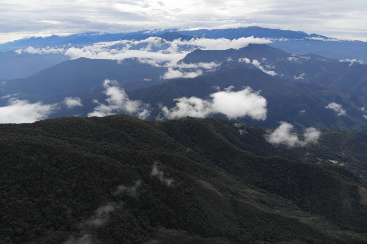
This diverse region encompasses the coastal river plain of the Magdalena River, pristine beaches, plains, swamps, wetlands, and the awe-inspiring Sierra Nevada de Santa Marta. The Sierra, the highest point in Magdalena, claims the title of the world’s highest coastal mountain, housing the towering Cristóbal Colón peak at 5,700 meters (18,700 feet) above sea level. This ecological haven teems with biodiversity, hosting indigenous communities and endemic species, making it a sought-after destination.
Magdalena stands as a melting pot where indigenous traditions, Colombian folklore, and natural wonders converge, establishing it as a distinctive and highly frequented tourist hotspot in Colombia.
Hiking Trails in Magdalena, Colombia
Next, I will provide you with information about the 4 hiking trails you shouldn’t miss in Magdalena. This is the rubric that will explain the difficulty level that will appear on each route.
Difficulty levels
Moderate
The terrain is flat, asphalted or paved and clearly marked. It is not very long and does not require excessive physical effort. Suitable for the whole family.
Medium
The terrain is mostly uncovered, there is unevenness, moisture and mud. The route requires significant physical effort and is not suitable for people with reduced mobility.
Difficult
The terrain is largely uncovered, there are steep climbs, uncertain weather conditions and high physical demands. The route is usually long and not suitable for the elderly, those with heart and respiratory diseases, children under 8 years old or pregnant women.
Hiking Trails in Santa Marta
Santa Marta is a magical city on the northern coast of Colombia, situated at the height of the Caribbean Sea. Consequently, this place is surrounded by beautiful beaches and high mountains.
In addition to its biodiversity, it is a city where the cultures of indigenous groups such as the Tayrona, Kogi, Kankwamo, Arhuacos, and Wiwa are very present. As a result, it has a unique cultural richness.
It is famous for its tropical climate and natural sites where you can enjoy numerous ecotourism activities, including hiking. For example: Tayrona National Natural Park, the Lost City, the Sierra Nevada de Santa Marta, and others.
Hiking in Tayrona National Natural Park
Tayrona National Natural Park, sacred to the Arhuaco, Kogui, Wiwa, and Kankwamo indigenous peoples, lies just 30 km (18 miles) from Santa Marta at its main entrance, El Zaino. A quick 40-minute drive brings you to this spiritually significant area.
Spanning 15,000 hectares, the park features diverse ecosystems—dry and humid forests, misty woodlands, beaches, lagoons, mangroves, rocky shores, coral formations, and seaweed meadows. It’s a biodiversity hotspot with 31 species of flying mammals, 26 large and medium-sized land mammals, and 396 bird species, including bats, howler monkeys, iguanas, and pelicans. The marine area boasts 180 fish types, hawksbill and green turtles, humpback whales, eels, and more.
Thrill-seekers can dive into ecotourism activities like bird watching, fauna and flora observation, snorkeling, diving, and over 30 km (18 miles) of ecological hiking trails. Tayrona National Natural Park is a direct ticket to nature’s wonders for adventure enthusiasts.
Important
To allow the terrain to rest, ecotourism activities are suspended on the following dates:
- February 1 to 15 (during the Kugkui shikasa season).
- June 1 to 15 (during the Saka Juso season).
- October 19 to November 2 (during the Nabbatashi season).
These dates are established by the park and the indigenous peoples.
The low season of the park is from February to June and August to December.
It is advisable to get vaccinated 15 days before the trip against yellow fever and tetanus.
The signal for online payments is not very good, so bring cash.
Pets are not allowed.
Opening hours: every day from 7:00 am to 5:00 pm. Some schedules may vary slightly depending on the site you want to go.
Price: there is an entrance fee to the park.
Website: https://www.parquesnacionales.gov.co/nuestros-parques/pnn-tayrona
Nueve Piedras Trail
Difficulty level: moderate.
The route is not very demanding. However, the temperature can be high for some people, so stay hydrated.
One-way distance: 2 km (1 mile) from the park entrance to Cañaveral Beach.
One-way duration: 1 hour and 30 minutes.
Climate: warm and dry.
Start the educational trail at Cañaveral, a quick 2.5 km (1.5 miles) walk or a bus ride from the main entrance. The path is paved and straightforward.
Commence your journey at the Chayirama Museum in Cañaveral, featuring 9 large oval stones leading to Cañaveral Beach—the first stop on the coastal walks. These stations represent natural forces.
Experience the wooded environment, coastal area, and cliff-top views along the way. The trail concludes at Cañaveral Beach.
Beyond a physical trek, this trail offers insight into the Tayrona and Kogui indigenous worldview. According to Kogui mythology, these stones played a crucial role in the creation of the first women.
Choose to return to the park entrance or extend your exploration to other beaches. This trail is a direct route to both cultural and natural immersion.
Important
I recommend starting the journey early in the morning; at that time, the temperature is not so intense, and the park is not crowded.
In the park, it usually rains in the months of May, July, September, and October. Although the rains are momentary, they could affect hiking, so I suggest going in the other months.
Trail to Cabo San Juan
Difficulty level: medium.
The route is long, and there are uphill sections. Similarly, due to the sun, it could be exhausting, so it’s important to stay hydrated.
One-way distance: 3 km (1.8 miles) from the park entrance to Cabo San Juan.
One-way duration: 2 hours.
Climate: warm and dry.
Start at El Zaino and head to Cabo San Juan after passing Cañaveral Beach. Walk through the jungle to Arrecifes, a camping area with a beach where swimming isn’t recommended.
Proceed to La Piscina Beach, perfect for a calm swim and sacred sea gratitude ceremonies. Finally, reach Cabo San Juan, acclaimed as Santa Marta’s most beautiful beach, surrounded by coconut palms, palms, and almond trees.
Interact with the Kogui community, spot wildlife like the needle-nosed caiman and howler monkeys. Stay, eat, and birdwatch in the area.
For the return, follow the same trail or take a boat to Taganga, a 30-minute ride. If you continue walking, explore other beaches like Boca del Saco, Bahía Concha, Bahía de Chengue, Gairaca, Neguanje, and Playa Cristal. Take your time; it’s advisable not to visit all in one day.
Important
Start early, stay hydrated, and do not swim in the beaches not recommended.
If you want to do long hikes, it’s good to hire a specialized guide.
If you are already inside the park, you do not have to pay anything to do this trail.
Hiking in the Sierra Nevada de Santa Marta National Natural Park
The Sierra Nevada de Santa Marta National Natural Park, located in Magdalena, César, and La Guajira, is just 42 kilometers (26 miles) from Santa Marta’s coastal area. A little over an hour’s drive by car takes you to this mountainous reserve.
The park spans from sea level to 2,800 meters (9,186 feet), culminating at over 5,700 meters (18,700 feet) with the renowned Sierra Nevada de Santa Marta. Culturally significant and featuring perpetual snows due to its elevation and thermal floors, the park is home to impressive peaks, such as the Cristóbal Colón peak, reaching approximately 5,700 meters (18,700 feet) above sea level.
This park houses different ecosystems, for example:
- Beaches.
- Cliffs.
- Forests.
- Paramos.
- Glaciers.
These ecosystems house 3,057 registered animal species, including 49 endangered ones like the spectacled bear, Andean condor, and white-tailed deer. There are over 126 plant species, with the critically endangered endemic frailejón, Tabaquillo de la Sierra, being noteworthy.
The territory is shared with indigenous communities residing in Kogui, Wiwa, Kankuamo, and Arhuaco reserves.
Due to the ecosystem’s fragility, numerous tourist activities are restricted. However, the hiking route to the Lost City remains open with specific restrictions.
Important
Tourist activities are prohibited in the high areas of the Sierra Nevada, including all snowy areas. Also, the San Lorenzo station is closed.
Pets are not allowed.
Hiking to the Lost City
Difficulty level: difficult.
The route is long, there are many mosquitoes, and it requires great physical fitness. There are paved sections of the trail, but most of it is on dirt.
Not recommended for older adults or women with high-risk pregnancies.
Altitude: in El Mamey, you will be at 140 meters (459.3 feet), and you will end up at 1,200 meters (3,937.0 feet) above sea level.
One-way distance: 32 km (19 miles).
One-way duration: 2 days.
Climate: warm and dry, and cold.
Known as Teyuna, this archaeological site was constructed by the Tayrona civilization around the 8th or 9th century A.D., predating the arrival of the Spaniards. Rediscovered in the 1970s after years of being concealed by dense vegetation, it showcases remarkable houses, terraces, and stone paths. Today, it stands as a favored tourist destination and a significant archaeological heritage.
The hiking route to reach Teyuna starts in the El Mamey village, approximately 3 hours away by 4×4 truck or Jeep from Santa Marta. It is advisable to have a meal before embarking on the trek.
Itinerary
- Day 1: After the El Mamey village, there are 3 stops where you can rest and buy drinks. The ascent is challenging, so hydrate frequently.
After crossing the point, you will reach the first camp, called Adán, at 450 meters (1,476 feet) above sea level. Here, you can eat and spend the night in hammocks. There is also a natural pool where you can cool off.
- Day 2: On the next day, continue your journey as early as possible; 5:00 am is an ideal time. The goal of this stretch is to reach the Wiwa settlement and then the Kogui settlement. In these places, you can experience cultural and spiritual activities.
On this day, you will walk about 15 km (9 miles). You will be able to see the Buritaca River.
That night, you can stay at the Paraíso Teyuna camp. This is 1 hour from the Lost City.
- Day 3: After an early breakfast, head to a trail where you will climb 1,200 steps. As you climb, you will begin to see the constructions until you reach the top, where the foundations of what was the Tayrona civilization are.
After that, you will return to the Paraíso Teyuna camp to eat and spend the night. It is not recommended to descend on the same day. It is always best to start in the morning.
- Day 4: This is the day of descent in the same order and through the same points where you climbed. It is not necessary to spend the night if you start early and walk at a good pace.
In the evening, you would be arriving at the El Mamey village, and from there, you can head back to Santa Marta.
The entire trail is surrounded by abundant endemic vegetation, and you can observe numerous species, such as hummingbirds and iguanas.
Important
Use insect repellent and bring enough food.
Throughout the journey, no mobile operator has a signal. Therefore, it is essential to go with a guide and hire round-trip transportation services from the starting village to Santa Marta.
Bring a swimsuit and hiking boots.
The itinerary may vary.
Price: there is an entrance fee to the park.
Website: https://www.parquesnacionales.gov.co/nuestros-parques/pnn-sierra-nevada-de-santa-marta/
Hiking in Via Parque Isla de Salamanca
Via Parque Isla de Salamanca, a protected area by the Colombian National Natural Parks System, safeguards the Ciénaga Grande de Santa Marta lagoon complex.
Covering 56,200 hectares, it’s situated 52 km (32 miles) from Santa Marta, reachable by car in about 1 hour and 15 minutes.
The park features coastal marine, mangrove forests, dry forests, and the Caribbean Sea. It hosts diverse plant species, from mangrove trees to cacti.
Notable residents include the American crocodile, West Indian manatee, ocelot, crab-eating raccoon, and the painted turtle. Moreover, it serves as the “international airport” for migratory birds.
In this area, ecotourism activities are allowed, such as:
- Bird watching.
- Boat rides.
- Wildlife and flora observation.
- Land hiking.
There are 3 land routes for hiking: Olivos, Clemanos, and El Cocodrilo. However, the main route is the Manglar trail, also called Los Cocos. This is an elevated platform over the Clarín Viejo canal.
Important
It is advisable to get vaccinated a few days before the trip against yellow fever, malaria, and tetanus.
Hiking on the Los Cocos Trail
Difficulty level: medium.
Although the route is not challenging, the terrain is muddy, very humid, and there is nothing to hold onto.
One-way distance: 2 km (1 mile) from the park entrance to the migratory bird area.
One-way duration: 1 hour and 30 minutes.
Climate: warm and humid.
Starting at the Los Cocos sector, the park entrance, this trail weaves through 31 points offering glimpses of the natural wonders around water arteries and mangrove forests.
Along the journey, guides provide insights into the vital role these biomes play, with stops allowing you to appreciate and learn about the diverse fauna and flora species.
The final destination is the “international airport” for migratory birds, where endemic and migratory birds peacefully coexist. It’s a common sight to witness herons in flight and entire families of ducks leisurely swimming in the mangroves.
You have the option to return using the same trail.
Important
The entire area is humid, some parts more than others, so wear waterproof boots.
Pets are not allowed, and scaring or disturbing birds to make them fly is also prohibited.
There may be occasions when the trail’s carrying capacity is exceeded. Therefore, the park reserves the right not to authorize entry.
Hours: every day from 8:00 am to 4:00 pm.
Price: there is an entrance fee to the park.
Website: https://www.parquesnacionales.gov.co/nuestros-parques/via-parque-isla-de-salamanca/
Climate in Magdalena, Colombia
The climate in this Colombian department is very diverse because it is directly subject to its geographical position, winds, and relief. These form different climatic conditions according to the altitude with respect to sea level.
There are three prevailing climates in the department:
- Warm dry climate (24°C to 30°C/75.2°F to 86°F): areas with this climate have warm and pleasant temperatures throughout the year, such as in Santa Marta, which is at sea level. However, sites farther from the coast tend to have a hotter temperature.
- Warm savannah climate (22°C to 28°C/71.6°F to 82.4°F): it is a climate similar to the previous one but tends to be a bit cooler. For example, we see it in the municipality of Fundación, which is 10 meters (32 feet) above sea level.
- Mountain climate (10°C to 22°C/50°F to 71.6°F): due to its altitude, temperatures are cool during the day and cold at night. Similarly, the climate often varies. This corresponds to the higher areas of the Sierra Nevada de Santa Marta, with an altitude of 5,700 meters (18,700 feet) above sea level.
The department has a rainy season and a dry season, the rainy season is generally from April to November, and the dry season from December to March, which is the best time for hiking.
Precipitation ranges from 1,000 mm (39 inches) to 2,000 mm (78 inches) per year.
Recommendations for Hiking in Magdalena
In order to have a better experience, I recommend following the rules of each of the places.
Usually, these are stipulated by government entities with the aim of preserving a specific ecosystem. The following are the most common ones:
- Do not litter.
- Do not take animals out of their habitats.
- Do not cut or uproot plants.
- No smoking.
- No hunting.
- If not clearly allowed, do not bring pets to protected areas.
- Do not throw anything into water sources.
- Avoid making fires in unauthorized areas.
- Do not take shortcuts or walk in prohibited areas.
- Do not consume alcoholic beverages or psychoactive substances.
- Do not go on excursions in dangerous weather conditions.
- Do not camp where it is not allowed.
- Do not play loud music with speakers.
On the other hand, to avoid setbacks, these tips will help you:
- Plan your journey in advance.
- Be cautious with online reservations; sometimes, they are scams.
- Look for information on official and government websites; there you can find it in English.
- Hire a reliable guide with a tourism guide card (national accreditation).
- If you have health problems, it is essential to inform your companions.
- Foreigners should undertake these journeys in groups.
- Start your tour early in the morning to avoid the sun and high temperatures.
What you should bring for Hiking in Magdalena
Hiking requires some preparations and equipment. Here are some suggestions for what you could bring:
- A backpack
- A hiking pole
- Comfortable and weather-appropriate clothing and footwear
- Identification documents
- Water and food
- A whistle
- A first aid kit
- Sunscreen and a hat
- Personal medications
- Change of clothes and footwear
- Local cash.
Contact us, and we will be more than happy to help you with your new adventure. Until next time, traveler!
More nature tourism experiences in Colombia
Here you will find a list of incredible destinations for hiking and other nature activities in Colombia:
- Best 9 Hiking Regions and 27 Routes in Colombia For Travelers
- Colombian Flowers: The Top 11 Most Representative Species
- Cocoa Guide Colombia – Features & Producers
More recommended hiking trails
- Discover the 7 Best Hiking Routes in Antioquia, Colombia
- The 7 Most Incredible Hiking Routes in Boyacá, Colombia
- The 9 Best Hiking Routes in Cundinamarca, Colombia
- Hiking in Santander, Colombia – 5 Incredible Routes
- How to Hike the Lengerke Trail in Colombia: A Complete Guide
- Hiking in Colombia’s Coffee Region: Top 5 Must-Visit Routes
- Must-Try Hiking Trails in Magdalena, Colombia
- Discover 4 Must-Visit Hiking Trails in Amazonas, Colombia
- The 6 Best Hiking Trails in Tolima, Colombia
- Climbing Tolima Volcano: A Challenging Andes Adventure
- 5 Must-Experience Hiking Routes in Huila, Colombia
- 5 Must-Experience Hiking Trails in Valle del Cauca, Colombia
- 6 Must-Experience Hiking Trails in Cauca, Colombia
- Explore 9 Scenic Trails in Eastern Plains, Colombia
- Hiking in Colombia: Checklist of 23 Essential Items to Bring
- The 9 Wild and Adventurous Hiking Routes in the Colombian Andes
- 9 Hiking Routes in Colombia Ideal for Families
