
Updated on 03/11/2024
Dear reader,
I would also like to recommend our Colombia travel guide, which provides a perfect overview of the tourist attractions in Colombia. Enjoy reading it!
The department of Cauca is a diverse region in terms of nature and culture, making it popular for its ecotourism potential, varied fauna, flora, and different ecosystems. Today, I will introduce you to the 6 hiking trails that you shouldn’t miss there.
Content
Geographical Overview of Cauca, Colombia
Cauca, in southwest Colombia, is defined by the Occidental and Central Andes. Its capital, Popayán, the “White City,” boasts colonial architecture.
The department includes 42 municipalities at an average altitude of 1,693 meters (5,554 feet), with the Puracé volcano summit reaching 4,700 meters (15,419 feet). Noteworthy are the Pacific Ocean’s Gorgona and Malpelo islands, part of Cauca.
Cauca is a diverse department in terms of topography, and its relief and geographical features offer a great variety of landscapes. For example, it includes:
- Canyons
- Islands
- Lagoons
- Moorlands
- Mountain Peaks
- Creeks
- Rivers
- Valleys
Cauca’s diverse landscapes, ideal for hiking and ecological tourism, contribute to its allure. As part of the Colombian Massif, spanning Cauca, Nariño, Huila, and Putumayo, this mountainous ecoregion is recognized for rugged terrain, high summits, and abundant biodiversity.
Hiking Trails in Cauca, Colombia
Next, I will provide information about the 6 main hiking trails in Cauca.
Difficulty levels
Moderate
The terrain is flat, asphalted or paved and clearly marked. It is not very long and does not require excessive physical effort. Suitable for the whole family.
Medium
The terrain is mostly uncovered, there is unevenness, moisture and mud. The route requires significant physical effort and is not suitable for people with reduced mobility.
Difficult
The terrain is largely uncovered, there are steep climbs, uncertain weather conditions and high physical demands. The route is usually long and not suitable for the elderly, those with heart and respiratory diseases, children under 8 years old or pregnant women.
Hiking Trail in Sotará
Sotará is a municipality located in the southern part of the department of Cauca, approximately 28 km (17 miles) from Popayán, about an hour by car. It sits at an approximate altitude of 2,726 meters (8,943 feet) above sea level.
Surrounded by imposing mountains exceeding 3,000 meters (9,842 feet) above sea level, Sotará is renowned for its impressive biodiversity, featuring a variety of flora and fauna in its mountainous ecosystems. This makes it an ideal destination for hiking.
Hiking on the Sotará Volcano
This is an active volcano with an approximate height of 4,420 meters (14,501 feet) above sea level, located 37 km (22 miles) from Popayán. It has four eruptive centers called:
- Cerro Negro
- Cerro Azafatudo
- Cerro Gordo
- Sotará
However, there is no historical record indicating that this volcano has ever erupted. Currently, it exhibits seismic activity and lava flows.
Ascent to the Sotará Volcano
Difficulty Level: Difficult.
The ascent is challenging, and as the route is typically done in a single day, it is very demanding.
The terrain has many uneven sections, including mud.
One-way distance: 12 km (7 miles).
One-way duration: 7 hours.
Altitude: You will ascend to 4,420 meters (14,501 feet) above sea level.
Climate: Cold, high-mountain climate.
To ascend the Sotará volcano, start at Paispamba, 1 km (0.6 miles) from Sotará, reachable by a 50-minute car ride. From Paispamba, take the Chapa trail, a 20-minute drive away.
The 5-hour trek from Chapa leads through a captivating high Andean forest with streams, oak trees, cafetillo and motilón plants, and ferns. Afterward, a páramo of 150-year-old frailejones awaits, often used for spiritual activities guided by the indigenous community of Ríoblanco.
Continuing to the summit, the trail becomes steep with sparse vegetation, culminating in a fog-shrouded summit. Embrace the panoramic view, capturing the moment significant in indigenous cosmology and offering a spiritual connection.
The return follows the same route.
Important
- This place is highly respected and valued by the indigenous people of Ríoblanco. Be very cautious at every step. Avoid stepping on the frailejones, do not litter, avoid shouting, and playing music.
- It is unclear if parking services are available.
- Do not approach the craters.
- I advise hiring a guide from the indigenous community of Ríoblanco for your safety and to enrich your experience. They will explain the historical context of the location, share their spiritual vision, and teach you about the surrounding nature.
Website: https://www2.sgc.gov.co/sgc/volcanes/VolcanSotara
Hiking Trail in Popayán
Popayán, the capital of Cauca, is situated at an altitude of approximately 1,760 meters (5,774 feet) above sea level. This historic city is famous for its colonial architecture, cobblestone streets, and rich cultural life. In terms of biodiversity, the surroundings of Popayán harbor cloud forests and a variety of bird species.
Hiking to El Duende Waterfall
Difficulty Level: Medium.
The terrain has many uneven sections and is very steep.
One-way distance: 5 km (3 miles).
One-way duration: 2 hours and 30 minutes.
Altitude: 1,780 meters (5,839 feet) above sea level.
Climate: Tropical climate.
El Duende Waterfall is a fascinating site with a 10-meter (32-foot) high water drop and a natural wall of 15 meters (49 feet). To visit it, you must reach the Clarete trail, which is 34 minutes by car from Popayán, about 22 km (13 miles).
The trail is clearly marked in this area. The route is a steep and demanding descent due to the high temperature and abundant vegetation along the way. Along the path, you will encounter small streams, water sources, and rocky areas.
There aren’t many details about the trail, but your guide will take you through specific points.
You can swim in the waterfall and take incredible photographs.
Important
- I suggest finding a guide in Popayán or Clarete.
- Bring a swimsuit.
Hiking Trail in Inzá
Inzá is located 2 hours and 30 minutes by car from Popayán, about 102 km (63 miles), at an average altitude of 1,754 meters (5,754 feet) above sea level.
This municipality is renowned for its production of high-quality coffee, thanks to its cool climate and fertile soils.
Its ecosystems include mountains and forests that harbor diverse species of fauna and flora, making hiking its trails a memorable experience.
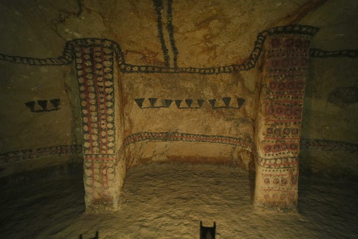
Hiking in the National Archaeological Park of Tierradentro
This UNESCO World Heritage site, declared in 1995, is an archaeological reserve preserving remnants of the pre-Columbian culture from the 4th to the 9th centuries. Located about 3 hours by car from Popayán, approximately 111 km (68 miles) away, the park showcases statues, collective tombs (hypogeas), and volcanic stones.
Once inhabited by agricultural and warrior societies such as Paeces, Pijaos, Yalcones, and Timanaes, engaging in ceramics, statuary, and metallurgy, the area is now home to the Nasa community, mestizo communities, and Afro-descendants. Situated in the Escaño area, the reserve spans a canyon zone across Belalcázar, the San Andrés de Pisimbalá reserve, and Inzá, named Tierradentro by the Spaniards.
These architectural samples are mainly concentrated in 5 sites:
- Alto de Segovia
- Alto del Aguacate
- Alto del Duende
- Alto San Andrés
- El Tablón
Important
- Remember that these paths or “altos” are trails through mountain valleys. However, the tombs are underground.
- There are numerous streams that flow into the Magdalena River in this area.
- There are stairs leading to vaults that are up to 9 meters (29 feet) deep.
Open hours: Every day from 8:00 am to 4:00 pm.
Price: There is an entrance fee to the park.
Website: http://www.colparques.net/TIERRA#aceptar
Hike on the Alto de Segovia, El Duende and El Tablón trails (Route 1)
Difficulty Level: Medium.
The path is inclined, with many stairs and descents. Therefore, good balance and footwear with grip are necessary.
There is illumination, although not very much.
One-way distance: 5.5 km (3.4 miles).
One-way duration: 1 hour and 45 minutes walking. However, it may take longer as you need to stop at each tomb to explore.
Climate: Temperate.
To start your journey, you can reach the park entrance, where you will be offered 2 routes: this one, which is the easier route, and the next one, considered the more complex.
Stages of the hike:
- Alto de Segovia: from the entrance to it is about 850 meters (2,788 feet). Afterward, you will ascend to Alto El Duende, about 750 meters (2,460 feet).
- Alto El Duende: you will ascend a few meters and descend about 2.8 km (1.7 miles) to El Tablón.
- El Tablón: if you want to continue to the San Andrés village, you will need to walk an additional 1.1 km (0.6 miles).
At Alto de Segovia and Alto El Duende, you will find the most colorful and well-preserved archaeological tombs in the park. In El Tablón, you will see 9 stone statues of animal figures and stones that still have an unknown origin. It is a fascinating place with ancient constructions.
You can return along the same route or, when you are at El Tablón, you can walk further to exit through the San Andrés village.
Important
I advise visiting the following tombs at Alto de Segovia:
- Tomb 8, the deepest.
- Tombs 9 to 12, the most colorful.
- Tomb 28, with urns containing human remains.
- Tomb 30, with clear patterns, designs, and drawings.
Hiking Trail through Alto de San Andrés and Alto El Aguacate (Route 2)
Difficulty Level: Difficult.
The trails are very steep, and there are many stones that could make you stumble.
One-way distance: 6.7 km (4 miles).
One-way duration: 3 hours and 15 minutes walking. However, it may take longer as you need to stop at each tomb to explore.
Climate: Temperate.
Although there is not as much variety of archaeological remains on this route, it is very interesting. You will pass through the following points:
- San Andrés Village: you will walk from here 850 meters (2,788 feet) to Alto de San Andrés; it is a very steep path.
- Alto de San Andrés: the path is 3.1 km (1.9 miles) to Alto El Aguacate, and it is long, with very steep descents and ascents.
- Alto El Aguacate: from here, you will cover 2.7 km (1.6 miles) to the main entrance. The path is flat, with a steep final stretch.
In the tombs on this trail, you will feel like Indiana Jones because there is no lighting. Therefore, you will need to use your phone or a flashlight to see the tombs clearly. A highlight of this route is the summit of Alto El Aguacate; it is truly impressive, and you can observe all the surrounding valleys.
According to many, that is the best view in all of Tierradentro!
On the trail, you will see many birds and a great variety of flora.
Hiking to the Inzá Pyramid
The Inzá Pyramid, a stepped structure over 1,000 years old in Tierradentro, is a 10-minute drive from Inzá’s main park (4.3 km or 2 miles). Theories about its origin differ, with some suggesting it was built by the Spaniards or indigenous Pijaos or Paeces for refuge.
Others argue it may be a geological formation shaped by faults and landslides, with three tunnels leading to the center, believed to be made by the Spaniards in search of gold or indigenous people hiding treasures.
Ascent to the Inzá Pyramid
Difficulty Level: Difficult.
One-way distance: Approximately 2 km (1 mile).
One-way duration: 2 hours.
Climate: Tropical.
Start the journey on the paved trail from Inzá to San Andrés de Pisimbalá. Walk about 10 minutes to a marked tree, indicating the pyramid on the left and El Danubio store on the right.
Proceed to the trail entrance a few meters ahead, leading to the not very high but steep pyramid. At the summit, believed to be a site of human sacrifices, enjoy the view.
During the descent, explore the three well-marked tunnels with lighting, showcasing impressive handmade structures and tomb-like features.
Return along the same route.
Important
- There is no parking near the pyramid. Therefore, you must leave your car on the main road before the ascent.
- I recommend hiring a guide; it will make your journey safer and more educational.
- Be careful with your movements and avoid making loud noises in the tunnels because there are bats, and you could scare them, causing them to flutter around.
- If you are afraid of tight spaces, I advise against entering the tunnels.
Price: There is a cost for entering the trail.
Hiking Trail in Miranda
Miranda is a municipality located 135 km (83 miles) from Popayán, with a journey of almost 3 hours. It is at an average altitude of 1,120 meters (3,674 feet) above sea level. Like Inzá, Miranda is famous for its production of high-quality coffee, local culture, and biodiversity. The region has a wide variety of birds and flora in its mountains and forests.
Hiking to El Charco del Burro
Difficulty Level: Difficult.
The path is unpaved and along the edge of a mountain. Therefore, it is very challenging. I suggest wearing shoes with grip.
One-way distance: Approximately 2 km (1 mile).
One-way duration: 1 hour.
Climate: Tropical.
El Charco del Burro is located in Miranda, 41 km (25 miles) from the central headquarters via the Miranda-Corinto route, in the La Cilia indigenous reserve. From the reserve, you will need to walk to reach this oasis, a stream where you can swim and cool off.
The trail starts at the reserve’s parking lot, and you will walk along an unpaved, steep route with little vegetation. It is a well-marked path but lacks landmarks. You will know you are close when you start seeing the Guengue River. The place is truly beautiful.
You can return along the same route.
Important
- Bring your swimsuit, and if you plan to spend a good amount of time at the site, bring food.
- Do not leave trash.
- Do not allow children to enter the stream without supervision.
Price: There is a cost for entering the stream and parking.
Other Important Hiking Routes in Cauca, Colombia
In Cauca, there are various parks and nature reserves. The most notable ones include Munchique National Natural Park, Puracé National Natural Park, Gorgona National Natural Park, and Doña Juana – Cascabel Volcanic Complex National Natural Park.
These are vast reserves of biodiversity, holding ecological significance. Due to the abundance of fauna and flora, they often offer ecotourism services related to hiking.
Unfortunately, they are currently closed due to the fragility of the ecosystem, lack of infrastructure, and their conservation status. It is not specified when they will reopen. Therefore, it is advisable to check their status on the official National Parks website before planning your trip.
Climate in Cauca, Colombia
The climate in the Cauca department is mainly determined by its relief and geographical position, resulting in different climatic conditions according to altitude.
There are four prevalent climates in Cauca:
- Tropical Climate (25°C to 28°C / 77°F to 82°F): Warm temperatures prevail throughout the year due to its proximity to the Pacific Ocean. It has high humidity and is prone to heavy rainfall. This can be observed in the municipality of Santander de Quilichao, located at an altitude of 1,071 meters (3,513 feet) above sea level.
- Humid Jungle Climate (22°C to 25°C / 71°F to 77°F): Typical of areas near the Pacific coast and some northwest regions of Cauca. It is characterized by high precipitation throughout the year, accompanied by warm temperatures and high humidity. These climatic conditions are common in Piedemonte, situated at 300 meters (984 feet) above sea level.
- Temperate Climate (12°C to 22°C / 53°F to 71°F): This is an intermediate temperature. It varies significantly depending on the altitude of the location—higher altitudes tend to be colder, and lower altitudes warmer. This is the typical climate of Popayán, located at an altitude of 1,760 meters (5,774 feet) above sea level.
- Cold High-Mountain Climate (Below 10°C / 50°F): Common in high-altitude areas in mountain ranges. Nighttime temperatures can drop below zero, and rain and snowfall are common. This is frequent in Cerro Santana, in the axis of the Western Cordillera, at an altitude of 3,170 meters (10,400 feet) above sea level.
Precipitation in Cauca
The main rainy season is from January to May and from October to December, with annual rainfall ranging from 1,000 mm to 7,000 mm. For hiking, it is recommended to go during the dry season in June, July, August, and September.
Recommendations for Hiking in Cauca
I suggest adhering to the rules of each location to have a better experience.
These rules are usually stipulated by government entities with the goal of preserving a specific ecosystem. Common rules include:
- Do not litter.
- Do not remove animals from their habitats.
- Do not cut or uproot plants.
- No smoking.
- No hunting.
- If not explicitly allowed, do not bring pets to protected areas.
- Do not throw anything into water sources.
- Avoid making fires in unauthorized areas.
- Do not take shortcuts or walk in prohibited areas.
- Do not consume alcoholic beverages or psychoactive substances.
- Do not go on excursions in dangerous weather conditions.
- Do not camp where it is not allowed.
- Do not play music with speakers.
Additionally, to avoid mishaps, consider the following tips:
- Plan your route in advance.
- Be cautious with online reservations; sometimes, they can be scams.
- Look for information on official government websites, available in English.
- Hire a reliable guide with a national tourism guide card.
- If you have health issues, inform your companions.
- Foreigners should undertake these journeys in groups.
- Start your journey early in the morning to avoid the sun and high temperatures.
What to Bring for Hiking in Cauca
Hiking requires some preparation and equipment. Here are some suggestions for what you could bring:
- A backpack
- A hiking stick
- Comfortable and weather-appropriate clothing and footwear
- Identification documents
- Water and snacks
- A whistle
- A first aid kit
- Sunscreen and a hat
- Personal medications
- Change of clothes and footwear
- Local cash
Feel free to contact us, and we will be more than happy to assist you with your new adventure. Until next time, traveler!
More nature tourism experiences in Colombia
Here you will find a list of incredible destinations for hiking and other nature activities in Colombia:
- Best 9 Hiking Regions and 27 Routes in Colombia For Travelers
- Colombian Flowers: The Top 11 Most Representative Species
- Cocoa Guide Colombia – Features & Producers
More recommended hiking trails
- Discover the 7 Best Hiking Routes in Antioquia, Colombia
- The 7 Most Incredible Hiking Routes in Boyacá, Colombia
- The 9 Best Hiking Routes in Cundinamarca, Colombia
- Hiking in Santander, Colombia – 5 Incredible Routes
- How to Hike the Lengerke Trail in Colombia: A Complete Guide
- Hiking in Colombia’s Coffee Region: Top 5 Must-Visit Routes
- Must-Try Hiking Trails in Magdalena, Colombia
- Discover 4 Must-Visit Hiking Trails in Amazonas, Colombia
- The 6 Best Hiking Trails in Tolima, Colombia
- Climbing Tolima Volcano: A Challenging Andes Adventure
- 5 Must-Experience Hiking Routes in Huila, Colombia
- 5 Must-Experience Hiking Trails in Valle del Cauca, Colombia
- 6 Must-Experience Hiking Trails in Cauca, Colombia
- Explore 9 Scenic Trails in Eastern Plains, Colombia
- Hiking in Colombia: Checklist of 23 Essential Items to Bring
