

Dear reader,
I would also like to recommend our Colombia travel guide, which provides a perfect overview of the tourist attractions in Colombia. Enjoy reading it!
Tolima, Colombia, renowned for its natural and cultural wonders, offers diverse landscapes perfect for memorable hikes. Here are the top 5 trails to explore.
Content
ToggleGeographical Overview in Tolima, Colombia
Tolima, located in the Andean region at the center of Colombia, boasts diverse geography with an average elevation of 3,280 feet above sea level. Comprising 47 municipalities, each with its distinct cultural and geographical features, notable spots include the capital, Ibagué, and Melgar, renowned for its hot springs.
The department’s terrain encompasses mountains, valleys, and plains, adorned with rivers and lagoons, notably the Magdalena River. Los Nevados National Natural Park is home to the towering Nevado del Ruiz volcano, reaching approximately 17,452 feet, offering stunning scenery and popular hiking trails, making Tolima a haven for ecotourism enthusiasts.
Hiking Trails in Tolima, Colombia
Below, I’ll tell you everything you need to know about these 5 hiking trails that you shouldn’t miss in the Tolima department. This is the rubric that will explain the difficulty level for each route.
Difficulty levels
Moderate
The terrain is flat, asphalted or paved and clearly marked. It is not very long and does not require excessive physical effort. Suitable for the whole family.
Medium
The terrain is mostly uncovered, there is unevenness, moisture and mud. The route requires significant physical effort and is not suitable for people with reduced mobility.
Difficult
The terrain is largely uncovered, there are steep climbs, uncertain weather conditions and high physical demands. The route is usually long and not suitable for the elderly, those with heart and respiratory diseases, children under 8 years old or pregnant women.
Hiking Routes in Murillo, Tolima
Murillo is a small municipality located southeast of Ibagué, 153 km (95 miles) away. The journey takes about 3 hours by car. It sits at an average altitude of 2,400 meters (7,874 feet) above sea level and has a cool climate.
This municipality is renowned for its beautiful mountain landscapes and thermal waters. Additionally, from Murillo, you can reach one of the entrances to Los Nevados National Natural Park, one of the most incredible hiking destinations.
Hiking in Los Nevados National Natural Park
Los Nevados National Natural Park, including Tolima, is an ecological and volcanic reserve housing the Nevado del Ruíz and Nevado del Tolima volcanoes, among others.
Activities like camping, wildlife observation, and hiking are permitted, providing a direct and immersive experience in this diverse natural setting.
For tourism, there are many trails leading to the summit edges or various natural attractions. Here are some:
- Laguna de Otún Trail
- Brisas Trail
- Conejeras Trail
- Laguna Verde Trail
- Aguacerales Trail
- Arenales Trail
- Termales de Cañón Trail
- Perlas Trail
- El Espolón Nevado del Tolima Trail
The choice of the route depends on the natural attraction you want to visit and, of course, your physical condition.
Important
Note that access to snow and glaciers is not recommended from any sector, and camping in the area has associated costs. Also, you must carry rescue insurance in this park.
In various park areas, camping is allowed, but you must have the necessary equipment as the nights can be extreme.
Pets are not allowed.
Opening hours: every day from 7:00 am to 2:00 pm.
Prices: entrance and overnight stay have a cost.
Website: https://www.parquesnacionales.gov.co/nuestros-parques/pnn-los-nevados/
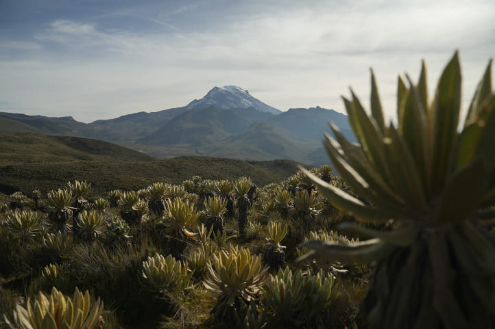
Ascent to Nevado del Tolima
Difficulty level: difficult.
The terrain is steep and rocky. This route reaches impressive altitudes.
One-way distance: 14 km (8 miles) before the snowy area via the El Espolón route.
One-way duration: 2 days.
Altitude: starting at 2,900 meters (9,514 feet) above sea level and ending at 4,600 meters (15,091 feet) above sea level. Ascent of 1,700 meters.
Climate: paramo climate.
Nevado del Tolima, a renowned snow-capped peak with volcanic activity, is a challenging yet rewarding adventure. To reach it, travel to Anzoátegui, three hours by car from Murillo (about 129 km or 80 miles). Start your journey from El Palomar vereda.
Day 1: Ascend to Finca Vancouver, the Palomar sector, and the base camp, Termales de Cañón, at 4,000 meters (13,123 feet). Camp overnight after a 10-hour walk. Enjoy the stunning views of the snow-capped Ruiz volcano. The trail takes you through Andean forests, paramos, and by the Bomboná lagoon with rich biodiversity.
Stay hydrated and well-fed due to the exhausting high-altitude ascent. Prepare for extreme night temperatures.
Day 2: Ascend to the Arenales sector, just before the summit, passing through extensive meadows and paramos with frailejones. Follow your guide’s instructions, be mindful of mud, and take in breathtaking views. Camp at Arenales, experiencing varying weather conditions at over 4,600 meters (15,091 feet).
The rocky terrain and lack of vegetation make camping challenging. Ensure a secure tent setup due to the slope.
Day 3: Descend along the same route, appreciating the beauty of the landscape.
Read about our full excursion to Nevado del Tolima for a detailed account of the experience.
Important
You must go with a guide, a maximum of 8 people can be in your group, and it’s essential to wear warm clothing, UV-protective glasses, food, drinks, and waterproof shoes.
It’s common for them to offer mules to carry your belongings. I don’t recommend it as they damage the ecosystem by stepping on frailejones. Sadly, in many cases, they are mistreated by those who carry them.
If you feel altitude sickness with symptoms like vomiting, dizziness, and difficulty breathing, do not continue ascending.
For camping, it’s essential to bring:
- A wind and rain-resistant tent
- A sleeping bag suitable for low temperatures
- An insulating mat
- Warm clothing
- Flashlight with spare batteries
- Portable cooking equipment
- Drinking water and enough calorie-rich food
- First aid kit
- Map and compass
- Trash bag
Remember to acclimatize in advance.
Hiking to Termales del Sifón
Difficulty level: difficult.
The complete route requires some physical effort, is not very long, but the terrain is swampy. Similarly, the weather is very unpredictable, with constant rain.
One-way distance: 1.5 km (0.9 miles) from the Sifón Trail to the hot springs.
One-way duration: 1 hour and 30 minutes.
Altitude: you’ll be at 2,950 meters (9,678 feet) at the starting point and at the hot springs at 4,000 meters (13,123 feet) above sea level. Ascent of 1,050 meters.
Climate: cold, rainy, and paramo.
To reach the stunning Sifón hot springs in Nevados Park, head to the park’s east side, the buffer zone, located between Manizales and Murillo. Murillo, just 30 km (18 miles) away, serves as a convenient starting point. Before the Sifón Trail, you’ll find Ventanas, where locals offer amenities like food and parking.
It’s recommended to park here and walk the 20 to 25 minutes to the Sifón Warehouse, the hot springs’ entry point. After receiving a wristband, embark on a one-hour walk to the hot springs. Bring a swimsuit and a change of clothes for a refreshing dip.
For the return journey to Ventanas and Murillo, follow the same route. Enjoy the breathtaking scenery and the therapeutic properties of the hot springs.
Important
I advise you to take appropriate clothing for cold weather, raincoat and boots.
In this area it is common to have altitude sickness. To avoid this, hydrate often, make acclimatization stops, do not eat sweet foods and do breathing exercises.
You can camp in this area. However, you must pay and have the necessary equipment because the weather is extreme at night.
Hiking Trails in Ibagué, Tolima
Ibagué is the capital of the Tolima department and is located at an altitude of approximately 1,285 meters (4,216 feet) above sea level. Known as the “Musical City” due to its rich tradition in folk and popular music, Ibagué also boasts numerous natural sites and forest reserves, providing opportunities to enjoy nature and outdoor activities.
Hiking in Parque Ecoturístico La Plata
La Plata Ecotourism Park is a natural reserve offering various outdoor recreational activities. A standout feature is the hike to La Plata waterfall, considered the highest in Tolima at 490 meters (1,608 feet). It’s an incredible location.
Hiking on the Tana Route
Difficulty Level: Medium.
Distance: 1 km (0.6 miles) one way from the park entrance to the waterfall.
Duration: 2 hours (one way).
Climate: Warm tropical.
To reach La Plata waterfall, go to the Pastales district, about 14 km (8 miles) from Ibagué. It’s a 30-minute car ride or you can take a bus or Jeep. Follow the marked route to the park entrance. It’s a 30-minute walk to the park, or you can drive to La Alcancía farm and walk an additional half-hour to the waterfall.
On the trail, you’ll pass a restaurant, Ibanazca caves, and reach the waterfall, then descend to the resting area. The hike takes over an hour. You can swim in the waterfall, and at the resting area, relax in hammocks and purchase lunch. Arrive before 2:00 pm, as meals sell out quickly.
The trail is filled with endemic vegetation and diverse wildlife like hummingbirds and butterflies. The return route is the same.
Important
If you plan to swim, bring a swimsuit and water shoes.
Pets are not recommended.
The trail can be demanding; take breaks if needed.
Prices: entrance to the park has a fee.
Opening hours: Tuesday to Sunday from 9:00 am to 2:00 pm.
Website: https://parqueecoturisticolaplata.com/
Hiking in the Combeima Canyon
The Combeima Canyon, situated at 2,200 meters (7,217 feet) above sea level, is an ecological transition zone within the Los Nevados National Natural Park. This breathtaking destination, approximately 30 kilometers (18 miles) southeast of Ibagué, Colombia, is home to condors, spectacled bears, foxes, and eagles.
Renowned for its natural landscapes and rich biodiversity, the Combeima Canyon is an impressive tourist spot. Various routes provide access to the canyon, offering different levels of difficulty for those seeking diverse hiking experiences.
Important
Activities such as camping without prior permission and bringing pets are prohibited.
Pets are allowed.
Hiking to the Combeima Canyon
Difficulty level: medium.
The terrain is slightly steep, with areas where vegetation can be dense. There are various stops, so you can take breaks.
Distance to cover: about 6 km (3 miles) including the return trail.
One-way duration: 3 hours.
Climate: tropical warm climate.
In Ibagué, take a bus or drive 32 km (19 miles) to Las Juntas. From El Silencio, use the cable car (with a fee) to reach La Rivera estate, the gateway to the Combeima Canyon.
Start the trail from the estate, passing through low mountains, animal houses, and crossing the canyon on another cable car. Climb 161 steps to the Los Sauces viewpoint, offering a stunning view. This area is a base for ascending the Tolima snow-capped mountain.
Return on a 3-hour trail, guided throughout, concluding at the main estate area.
Important
This is not the only hiking route to the canyon. In fact, many people choose to use the vehicular route from the center of Las Juntas, which is about 18 km (11 miles). In that case, you can go to the canyon by walking, biking, driving, riding a motorcycle, or horseback riding.
You don’t need to pay the entrance fee or be accompanied by a guide on that trail.
The hiking route from the estate is just one of the options you have to choose from.
Opening hours: Saturdays and Sundays from 8:00 am to 8:00 pm.
Price: There is a cost for park entry and the cable car.
Hiking Routes in Gualanday, Tolima
Gualanday is a charming municipality located in the eastern foothills of the Central Andes. At an approximate altitude of 800 meters (2,624 feet) above sea level, it is 34 km (21 miles) from Ibagué, taking around 30 minutes by car.
This place stands out for its natural richness and biodiversity. It’s perfect for ecotourism activities such as hiking on natural trails or birdwatching.
Ascent to Cerro El Fraile
Difficulty level: medium.
The terrain is short, dry, and quite steep, with fairly steep ascents. The ascent can take longer as it gets closer to noon when the temperature becomes scorching.
One-way distance: about 1 km (0.6 miles) to the summit of the hill.
One-way duration: 50 minutes.
Climate: tropical warm climate.
To go to Cerro El Fraile, you need to reach Gualanday, park your vehicle, and look for El Camino al Cerro. The ascent takes about 50 minutes, and it is steep, entirely on dirt. However, there are rocky areas.
The vegetation tends to be dry and may obstruct parts of the trail, so be careful not to trip or stray from the path. As there aren’t many trees, the temperature is warm, and the sun is intense.
At the summit, you’ll find a white cross and have a wonderful panoramic view of the surrounding mountains and metropolitan areas of Ibagué and its surroundings. It’s the perfect place to take excellent photos.
The return route is the same as the one you took to ascend.
Important
It is essential to stay hydrated and use sunscreen, a hat, or a cap.
You can bring your pet.
Hiking Routes in Fálan, Tolima
Fálan, located at 1,800 meters (5,905 feet) above sea level and 2 hours from Ibagué (about 122 km or 75 miles), is a captivating destination for hiking enthusiasts. This charming town provides a unique experience amidst nature, offering beautiful mountainous landscapes and trails surrounded by lush vegetation.
A major natural attraction in Fálan is the Ciudad Perdida Reserve.
Hiking in the Ciudad Perdida Reserve
This protected reserve houses an ancient mine and Spanish citadel believed to have been built over a thousand years ago. Here, visitors can explore archaeological ruins and immerse themselves in ancient history and culture.
For extreme sports enthusiasts, there are canopy and canyoning services.
Hiking towards the ruins of Ciudad Perdida
Difficulty level: medium.
The terrain is challenging, humid, and involves various ascents.
It gets very hot.
One-way distance: 6 km (3 miles) to the ruins of Ciudad Perdida.
One-way duration: 3 hours.
Climate: tropical warm climate.
The Ciudad Perdida Reserve is just 5 minutes from Fálan’s main park. The route to the ruins of Ciudad Perdida is unique in Colombia, combining ecological and historical elements. This location boasts rich biodiversity and water sources. Furthermore, its architecture and history have earned it the designation of historical heritage in Tolima.
The path runs along the edge of a river, and you’ll cross three spectacular waterfalls where you can take a dip:
- Humboldt Waterfall
- Sabio Caldas Waterfall
- San Joaquín Waterfall
After passing through five tunnels, you’ll reach the preserved ruins of Ciudad Perdida, featuring walls, tunnels, and stone warehouses from its historical past.
The route offers beautiful landscapes with a profusion of endemic trees, creating a refreshing environment surrounded by numerous birds like toucans, hummingbirds, woodpeckers, and Andean sparrows.
Notably, this site holds historical significance, having been worked on or visited by key figures in Colombian history such as Francisco José de Caldas, José Celestino Mutis, Alexander Von Humboldt, and Simón Bolívar.
The return journey follows the same route taken for the ascent.
Important
Bring swimwear and water shoes.
It is not recommended to bring pets.
Arrive early; around noon, the temperature becomes very intense.
Opening hours: every day from 8:00 am to 6:00 pm.
Price: There is a cost for entry to the reserve.
Website: https://ciudadperdidafalan.co/
Climate in Tolima, Colombia
The climate in Tolima is diverse due to its geographical location and topography. In general, the department experiences a tropical mountain climate, with some variations depending on altitude and region.
The following three climates prevail in the department:
- Warm-Tropical Climate (25°C to 30°C/77°F to 86°F): A warm and humid climate throughout the year. There are frequent rains, especially from April to November, making the temperature cooler and more moderate. This climate is observed in Honda, which is at an elevation of 229 meters (751 feet) above sea level.
- Warm-Temperate Climate (18°C to 22°C/64°F to 71°F): A climate where the temperature tends to be higher and humid. It is common in Ibagué, which is at an altitude of 1,285 meters (4,215 feet) above sea level.
- Cold-Paramo Climate (8°C to 16°C/46°F to 60°F): In higher mountainous areas like the Los Nevados National Natural Park, with altitudes exceeding 5,000 meters (16,404 feet) above sea level, a cold and windy climate is experienced. Nighttime temperatures here can drop below 8°C.
Precipitation in Tolima, Colombia
Rainy seasons in most parts of the department occur from March to May and September to November, with annual rainfall ranging from 1,000 to 3,000 millimeters (39.3 to 118.11 inches).
Therefore, for hiking, I recommend going during the dry season, which spans from June to August and December to January.
Recommendations for Hiking in Tolima
To have the best experience, it is advisable to follow the rules of each location. These rules are usually stipulated by government entities aiming to preserve specific ecosystems. Common rules include:
- Do not litter.
- Do not remove animals from their habitats.
- Do not cut or uproot plants.
- No smoking.
- No hunting.
- If not clearly allowed, do not bring pets to protected areas.
- Do not throw anything into water sources.
- Avoid making fires in unauthorized areas.
- Do not take shortcuts or walk in prohibited areas.
- Do not consume alcoholic beverages or psychoactive substances.
- Avoid hiking in dangerous weather conditions.
- Do not camp where not allowed.
- Do not play music with speakers.
Additionally, to avoid mishaps, consider the following tips:
- Plan your route in advance.
- Be cautious of online reservations; they can sometimes be scams.
- Seek information on official and government websites; English versions are often available.
- Hire a reliable guide with a tourism guide card (national accreditation).
- If you have health issues, inform your companions.
- Foreigners should undertake these journeys in groups.
- Start your journey early in the morning to avoid the sun and high temperatures.
What to Bring for Hiking in Tolima
Hiking requires some preparations and equipment. Here are some suggestions for what you might bring:
- A backpack
- A hiking pole
- Comfortable and weather-appropriate clothing and footwear
- Identification documents
- Water and snacks
- A whistle
- A first aid kit
- Sunscreen and a hat
- Personal medications
- Change of clothes and footwear
- Local cash.
Contact us, and we will be more than happy to assist you with your new adventure. Until next time, traveler!
More Nature Tourism Experiences in Colombia
Here is a list of incredible destinations for hiking and other nature activities in Colombia:
- The Best Hiking Routes in Colombia.
- The Most Representative Flowers in Colombia.
- Cacao Guide in Colombia.
More recommended hiking trails
- Discover the 7 Best Hiking Routes in Antioquia, Colombia
- The 9 Best Hiking Routes in Cundinamarca, Colombia
- Must-Try Hiking Trails in Magdalena, Colombia
- Discover 4 Must-Visit Hiking Trails in Amazonas, Colombia
- Explore 9 Scenic Trails in Eastern Plains, Colombia
- 5 Must-Experience Hiking Trails in Valle del Cauca, Colombia
- 6 Must-Experience Hiking Trails in Cauca, Colombia
- 5 Must-Experience Hiking Routes in Huila, Colombia
- The 6 Best Hiking Trails in Tolima, Colombia
- The 7 Most Incredible Hiking Routes in Boyacá, Colombia
- Hiking in Santander, Colombia – 5 Incredible Routes
- Hiking in Colombia’s Coffee Region: Top 5 Must-Visit Routes
