
Updated on 04/19/2024
Dear reader,
I would also like to recommend our Colombia travel guide, which provides a perfect overview of the tourist attractions in Colombia. Enjoy reading it!
Colombia is a perfect destination to enjoy outdoor activities such as hiking, where the incredible biodiversity and fascinating landscapes will leave you in awe. Best of all, you can share this experience with your family, since hiking allows you to enjoy activities such as bird watching, horseback riding, plant observation and many more. In this blog, I will tell you about the best hiking trails ideal for families in Colombia.
Content
Geography of Colombia
Colombia, located in the northwest of South America, has a diverse geography that ranges from the majestic mountain ranges of the Andes, with its imposing peaks in the Sierra Nevada de Santa Marta, to extensive plains such as the Amazon and Orinoco. In addition, its Caribbean and Pacific coasts offer paradisiacal beaches and marine ecosystems rich in biodiversity. In short, this tropical country is home to a variety of landscapes that make it a captivating destination.
Keep in mind that depending on the hiking site you choose, you can find different geographical conditions that influence the experience of its routes.
Hiking Trails for Families in Colombia
Now I will give you the information of the best 9 hiking trails for families in Colombia. Some are very popular and others are less known.
Difficulty levels
Moderate
The terrain is flat, paved, or cobblestoned, clearly marked, not too long, and doesn’t require excessive physical effort.
Suitable for all ages.
Intermediate
The terrain is mostly uncovered with slopes, humidity, and mud. The length of the trail requires considerable physical effort.
Not suitable for people with mobility issues.
Hiking in Cerro de Monserrate, Bogotá
Difficulty level: Intermediate
Distance: 2,350 meters (7,700 feet), climbing almost 450 meters (1,475 feet) in altitude with 1,605 steps.
Duration: Over 1 hour and 30 minutes.
Altitude: Starting point at 2,700 meters (8,860 feet) above sea level and endpoint at 3,150 meters (10,350 feet) above sea level.
Climate: Cold.
Monserrate is a mountain located east of the city, probably the most renowned hiking route in the capital. You can hike it, take the funicular, or the cable car, but I suggest hiking it and visiting the Basilica Sanctuary of Señor Caído de Monserrate upon arrival.
Due to the experience it offers, it’s common to see entire families ascending this route because although it’s long, there are different easier ways to climb it, pets are allowed, and there are food spots.
The view is truly breathtaking, and despite requiring significant physical effort, it’s worth it. However, I recommend going on weekdays because it tends to be very crowded on weekends.
At the top you can enjoy a breathtaking view and delicious local dishes with your family. Surely the children will love to have the traditional chocolate with cheese.
Price: Pedestrian entry is free.
Website: https://monserrate.co/
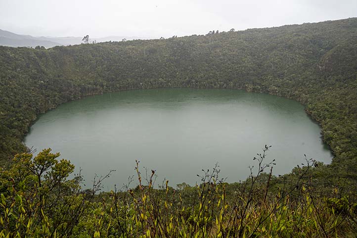
Hiking in Laguna de Guatavita, Sesquilé
Difficulty level: Moderate
Distance: 1.2 km (0.74 miles) one way to the lagoon.
Duration: 2 hours.
Altitude: Starting point at 2,559 meters (8,393 feet) above sea level and endpoint at 3,100 meters (10,170 feet) above sea level.
Climate: Temperate and cold.
Laguna de Guatavita is the perfect place to admire nature and learn about indigenous culture as it’s associated with the Colombian municipality Guatavita, which was the religious capital of the Muisca people.
The hike to the lagoon is ideal for telling children the legend of El Dorado, which recounts the story of a city entirely made of gold by the Muisca. Not only was the city made of gold, but it’s also said that in the Laguna de Guatavita, a ritual was performed to inaugurate the new chief of the village, where he covered himself in gold dust and submerged with a large amount of treasures. Additionally, it was believed that the presence of gods resided there, so gold and gemstones were usually thrown into it.
The area surrounding the lagoon is 613 hectares in size and, on the way, you can border the Embalse de Tominé and stroll along a quiet cobblestone path full of nature.
During this route, you’ll find 6 stops and walk 200 meters (656.1 feet) between each one until reaching the 3 viewpoints of the lagoon. There are food and souvenir stores on-site.
The view is incredible, the hike is fun, and you can take excellent photographs.
Important
- I recommend bringing cash as there is not enough signal for card machines to function.
- Remember that parking vehicles, camping, bringing food, or pets are not allowed at this site.
Price: The park entrance has a different cost for Colombians and foreigners.
Website: https://parques.car.gov.co/PaginaWeb/PaginaEstatica/Guatavita/QueHacer.aspx
Hiking in Parque Nacional Natural Farallones de Cali, Cali
Parque Nacional Natural Farallones de Cali is a protected natural area that mainly encompasses a set of mountains between the Andes and the Colombian Pacific. One of the main entry points, called El Topacio, is located in the Pance district, via Pance-Cali. It’s a 1-hour drive from Cali, about 1 km (0.6 miles).
The Farallones de Cali are the youngest rock formations of the Western mountain range.
This area has great biodiversity, with species that you can observe with your family such as birds, amphibians, reptiles, and mammals, among which the puma and the Andean bear stand out.
Something interesting about this park is that there are 4 ecosystems that you can visit:
- Sub-Andean humid forest
- High Andean humid forest
- Tropical rainforest
- Paramo
In these different environments ecotourism activities are allowed, particularly fauna and flora observation, environmental research, non-commercial photography and hiking.
This reserve is very large and there is much to discover.
Hiking to the Atractivo Burbujas
Difficulty Level: Moderate. The route is flat and short. The trail is clearly marked.
Distance to Cover One Way: Less than 1 km (0.6 miles).
One-Way Duration: 30 minutes.
Climate: Humid tropical climate.
The Burbujas puddle is a deep part of the Pance River where you can swim with your family. It features a small waterfall that creates movement and bubbles in this water source.
To visit the Atractivo Burbujas, you must reach the El Pato area in the Pance district. It’s a 1-hour drive from Cali, approximately 1 km (0.6 miles).
Once you pass the park entrance, you’ll need to walk a few minutes until you reach the wooden bridge over the Pance River. The view is breathtaking, and the trail is flat.
And the best part is that it’s not a long trail. However, once at the Burbujas puddle, you can walk around this water source and explore the surrounding biodiversity.
You can swim and cool off. The water is very cold.
The return route is the same.
This trail is flat and surrounded by lots of endemic vegetation.
Important
- Bring a change of clothes and sunscreen.
- There are many mosquitoes.
- This pool is deep. Therefore, be cautious if you don’t know how to swim or if you’re with children. In that case, don’t leave them alone, and if necessary, use floaties.
Price: There is an entrance fee to the park.
Website: https://www.parquesnacionales.gov.co/nuestros-parques/pnn-farallones-de-cali/
Hiking in San Cipriano Nature Reserve, San Cipriano
San Cipriano Reserve is an area that protects the San Cipriano and Escalerete rivers and their surrounding forests. Situated in the heart of the Pacific coast, with a vast ecosystem of tropical rainforest, it’s considered the fourth wettest and rainiest area in the world.
Its fauna and flora are an extraordinary resource, you can observe orchids, palms, spectacled bears and guacharacos. In addition, there is a butterfly farm and camping is allowed in its camping area.
Refugio del amor Trail
Difficulty Level: Intermediate.
Distance to Cover One Way: 1 km (0.6 miles).
One-Way Duration: 1 hour.
Climate: Humid tropical climate.
This route is located on the main trail of the San Cipriano Reserve, about 20 minutes from the town. The path is clearly marked, and you’ll pass by small streams and waterfalls.
The first stop is at the Refugio del amor Waterfall, where you can swim a bit and cool off. The temperature during the hike can be exhausting.
Before reaching the waterfall, you can enjoy 4 water sources, including small waterfalls, pools, and other smaller streams from the two main rivers, where you can refresh yourself with children or family members who can’t swim as they’re not very deep. At the fifth water source, you will have completed the route.
The trail is marked, and you can observe a wide variety of plants and insects. You may even see frogs jumping and butterflies fluttering.
At the end of this path, you’ll find other routes you can continue on. Additionally, there will be water sources where you can go tubing.
Important
You can return along the same trail. However, in this reserve, there are other attractive trails that I recommend doing with your family:
- Trail to La Plateada pool
- Trail to Los Sábalos pool
- Trail to the Butterfly Garden and the Muchillá Shrimp Kiosk.
This area is very humid, so wear light clothing and water shoes. Also, bring bags or plastic protectors to cover your belongings if you get into the river.
Guided tours are also offered in the reserve, and there is a restaurant.
Price: There is an entrance fee.
Website: https://cvc.gov.co/centro-educacion-ambiental-san-cirpiano
Hiking in La Plata Ecotourism Park, Ibagué
La Plata Ecotourism Park is a natural reserve that offers various outdoor recreational activities for the whole family. Among them, sports and hiking to La Plata waterfall stand out, considered the highest in Tolima, with 490 meters (1,608 feet) in height. It’s an incredible place.
Tana Route Hiking
Difficulty Level: Intermediate. Some areas have mud and are steep. Similarly, there are sections where you’ll need to climb up and down very rustic stairs.
Distance to Cover One Way: 1 km (0.6 miles) from the park entrance to the waterfall.
One-Way Duration: 2 hours.
Climate: Warm tropical climate.
To reach this waterfall, you must go to the Pastales village, which is about 14 km (8 miles) from Ibagué, a 30-minute drive by car. You can also go by bus or Jeep.
Once there, you will be able to see the route to the park entrance. This will not be difficult, it is clearly marked. From there, you will walk about 30 minutes to the park or you can drive and park your vehicle at the Finca La Alcancía and then walk another half hour to the waterfall.
On the way to the waterfall, you will first find the restaurant, where you can eat delicious local food and rest before or after the hike to the waterfall. Swimming is allowed in this water source, it is really not very deep, the water is cold and very refreshing. If you go to the rest area, you can lie down in the hammocks. They sell lunch there. However, I advise you to go before 2:00 pm, they are usually sold out very quickly.
The trail is covered with endemic vegetation and various animal species, such as hummingbirds, butterflies, and lizards. It’s the perfect route for animal-loving family members.
The return route is the same as the one you came on.
Important
- If you plan to swim, bring a swimsuit and water shoes.
- Pets are not recommended.
- The trail is somewhat demanding; make stops if necessary.
Price: There is an entrance fee to the park.
Website: https://parqueecoturisticolaplata.com/
Hiking in Ciudad Perdida Reserve, Falán
If you want to learn about history with your family, this protected reserve housing an ancient Spanish mine and citadel is the ideal place. In fact, it’s believed to have been built over a thousand years ago. Here, visitors can explore archaeological ruins and immerse themselves in ancestral history and culture.
And for extreme sports enthusiasts, there are canopy and canyoning services perfect for enjoying with family.
Hiking to the Ruins of Ciudad Perdida
Difficulty Level: Intermediate. The terrain is challenging, wet, and there are several ascents. It gets very hot.
Distance to Cover One Way: 6 km (3 miles) one way to the ruins of Ciudad Perdida.
One-Way Duration: 3 hours.
Climate: Warm tropical climate.
This reserve is located 5 minutes from the main park of Falán. The route to the ruins of Ciudad Perdida is unique in Colombia in terms of its ecological and historical components. This place has a large amount of biodiversity and water sources. Additionally, due to its architecture and history, it has been declared a historical heritage of Tolima.
The path runs along the edge of a river, and you’ll cross 3 spectacular waterfalls where you can bathe and swim:
- Humboldt waterfall
- Sabio Caldas waterfall
- San Joaquín waterfall
Then, you’ll pass through 5 tunnels and reach the ruins of Ciudad Perdida. From what once was this place, walls, tunnels, and stone warehouses are still preserved.
The route has beautiful landscapes and a large number of endemic trees that make the area very cool and surrounded by numerous birds, such as toucans, hummingbirds, woodpeckers, and Andean sparrows.
Something very interesting is that in this site, very important characters in Colombian history worked or stayed, such as Francisco José de Caldas, José Celestino Mutis, Alexander Von Humboldt, and Simón Bolívar.
The return route is the same as the one you came on.
Important
- Bring a swimsuit and water shoes.
- Pets are not recommended.
- Arrive early; around noon, the temperature is very strong.
Price: There is an entrance fee to the reserve.
Website: https://ciudadperdidafalan.co/
Hiking in Tayrona National Natural Park, Santa Marta
Tayrona National Natural Park is part of the sacred territory of the four indigenous peoples (Arhuaco, Kogui, Wiwa, and Kankwamo). The main entrance, El Zaino, and the park ticket office are located 30 km (18 miles) from the metropolitan area of Santa Marta, about a 40-minute drive.
Moreover, this area is fundamental to the worldview and spirituality of the indigenous groups. So, here you can enjoy nature and learn more about the indigenous communities with your family.
It covers an area of 15,000 hectares where there are various types of forests, such as dry, humid, and cloudy forests. Additionally, you can observe beach ecosystems, lagoons, mangroves, and rocky coastlines. On the other hand, in the marine area, there are coral formations and seaweed meadows.
Similarly, there are numerous species that you can observe through ecotourism activities. For example, bats, howler monkeys, iguanas, pelicans, hawksbill turtles, whales, among others.
In the park, families can engage in ecotourism activities such as bird watching, wildlife observation, snorkeling, diving, and hiking. There are over 30 km (18 miles) focused on ecological hiking.
Important
To allow the terrain to rest, ecotourism activities are suspended on the following dates:
- February 1st to 15th (during Kugkui shikasa).
- June 1st to 15th (during Saka Juso).
- October 19th to November 2nd (during Nabbatashi).
- The park’s low season is from February to June and August to December.
- It is advisable to get vaccinated against yellow fever and tetanus 15 days before the trip.
- The signal for online payments is not very good; bring cash.
- Pets are not allowed.
Nueve Piedras Trail
Difficulty Level: Moderate. The trail is not very demanding, making it suitable for children. However, the temperature can be high for some people, so it’s ideal to stay hydrated.
Distance to Cover One Way: 2 km (1 mile) from the park entrance to Cañaveral Beach.
One-Way Duration: 1 hour and 30 minutes.
Climate: Warm and dry.
This educational trail, with environmental interpretation, starts in the sector called Cañaveral, you can take a bus from the main entrance of the park or walk 2.5 km (1.5 miles). The route is paved and light.
Once at Cañaveral, you will start this journey at the Chayirama Museum. Next, you’ll see 9 large oval-shaped stones. There are a total of 9 stations to reach Cañaveral Beach, which is the first beach on the park hikes. There are many points that are perceived as personifications of natural forces.
This trail will allow you to contemplate the wooded environment, the coastal area, and from its viewpoint, the top of some cliffs. Finally, you’ll arrive at Cañaveral Beach.
The goal of this route is to understand the worldview of the Tayrona and Kogui indigenous people. One version of the Kogui myth conceives these stones as a vital part of the birth of the first women.
You can return via the same trail to the park entrance or continue to other beaches.
Price: There is an entrance fee to the park.
Website: https://www.parquesnacionales.gov.co/nuestros-parques/pnn-tayrona
Hiking in Maikuchiga, Leticia
In the Tikuna language, Maikuchiga means “history of monkeys,” and indeed, this natural reserve that rehabilitates primates is perfect for learning with your family about these adorable animals. To reach Maikuchiga, you must navigate 45 minutes by boat from Leticia. First, you’ll pass through the Amacayacu River, around 15 minutes until you reach the Amazon River. After navigating downstream, you’ll arrive at the community of Mocagua, where the reserve is located, approximately 70 km (43 miles) from Leticia.
Upon arriving on the island, you can start the tour by heading to the primate rehabilitation center.
Maikuchiga primate reserve is a beautiful tourist destination that, as mentioned, rehabilitates monkeys. It offers visitors the opportunity to experience the beauty and biodiversity of the Amazon rainforest with their family or groups of friends in a unique way, as you can observe the species in their natural environment.
The island is home to titi monkeys, capuchin monkeys, squirrel monkeys, flying monkeys, squirrel monkeys, spider monkeys, and other species that have suffered from poachers. Many have lost their mothers and families. Additionally, you can observe birds such as macaws, toucans, and parrots, an activity that children will love.
An interesting fact is that in the past, the Mocagua people consumed these primates, but now, thanks to ecotourism, they make efforts to preserve them.
This reserve offers accommodation and restaurant services.
Ome Mai Trail Hiking
Difficulty Level: Moderate.
The trail is flat and partly paved. There are several stops.
Distance to Cover One Way: 1 km (0.6 miles) along the island.
One-Way Duration: 40 minutes.
Climate: Warm and humid.
The walk is about 40 minutes, initially on a paved trail, then on land. During the Ome Mai route, you will pass through the island’s village, a stream, and a jungle path on land, surrounded by trees.
Then, you’ll walk to where the animals are, which are being trained to live on their own in the jungle. They are fed in a small building, and there you can observe them. But remember that this is a sanctuary, so the animals are not for display. I do not recommend feeding them with unauthorized food or letting children touch them as if they were ornaments.
You can return via the same trail.
Important
- Be aware that there is a lot of mud here.
- During the route, you will receive several talks about the conservation and protection of the Amazon ecosystem.
- You can stay and eat in the village.
- If you go in a group or with your family, it’s better if it’s smaller than 5 people.
- Bring waterproof boots and insect repellent.
Price: There is a cost for entry to the island, as well as for the area where the monkeys are.
Website: https://www.maikuchigafundacion.org/ome-mai-y-visita-al-centro
Hiking in Cocora Valley Natural Reserve, Salento
Cocora Valley is an iconic place in Colombia known for being the home of Colombia’s national tree, the wax palm of Quindío. This is considered the tallest palm tree in the world, reaching heights of up to 60 meters (196 feet).
Hiking in the Bosque de Palmas Trail
Difficulty Level: Intermediate.
- The complete route through the valley requires some physical effort. It’s long, the terrain is marshy, and the weather is very unpredictable.
- It’s very practical to prepare, and if you have mobility or balance problems, I don’t recommend it. Children can do it, but at a slow pace.
Distance to Cover One Way: 14 km (8.7 miles) through the entire valley.
One-Way Duration: 3 hours.
Altitude: You’ll be at 2,000 meters (6,561 feet) at the starting point and end the Palm Forest trail at over 2,400 meters (7,874 feet) above sea level.
Climate: Cold, rainy, and cloudy.
This place is perfect for family hiking due to its different mountainous landscapes and trails. The most well-known route is the Bosque de Palmas Trail. Imagine how fascinating it is to walk through fields of wax palms and cloud forests, because it’s possible there.
Additionally, you can be amazed with your family by seeing native fauna such as hummingbirds, yellow-eared parrots, opossums, and butterflies.
This trail is initially light and goes completely through the valley, it starts at the entrance, there is parking there or you can arrive in Willys, the typical car of the area. The route takes you first through the two viewpoints, when you reach them you will have walked about 2.5 km (1.55 miles).
Continuing, you will pass through a foggy forest about 4 km (2 miles). 2 km (1 mile) later, you will have reached the House of Hummingbirds.
That part of the route is slippery because there is a lot of mud, so it’s essential to wear appropriate footwear and assist the children. Then, you’ll encounter hanging bridges and finally, the humid forest. The entire route is marked.
Important
- I suggest going from December to February and from July to August and starting the hike before 11:00 am. The earlier, the better and safer. At 6:00 pm, the Willys depart back from the valley.
- I advise you to wear comfortable clothing that adapts to weather changes and is waterproof, as it rains a lot in this area, but the sun can come out suddenly.
- As such, camping is not allowed in the valley. However, you can camp at the restaurants located next to its entrance. You can bring your own tent or they will rent you one. The night here is great; you’ll literally sleep under the stars!
- To spend the night, bring enough food for you and your family. During the week, the restaurants close early. Even if you don’t spend the night, bring snacks and hydration for the trail.
Prices: The entrance has a cost, as well as camping.
Website: http://www.colparques.net/COCORA
Tips for Hiking in Colombia
To ensure a hassle-free experience, I recommend following the rules of each hiking destination.
These rules are usually set by governmental entities with the goal of preserving specific ecosystems. Here are the most common ones:
- Leave no trash behind.
- Do not disturb animals in their habitats.
- Avoid cutting or uprooting plants.
- No smoking.
- Leave pets at home.
- Refrain from littering in water sources.
- Stick to designated trails; avoid shortcuts or unauthorized areas.
- Avoid consuming alcohol or psychoactive substances.
- Do not embark on hikes in dangerous weather conditions.
- Keep the music off; respect the tranquility of nature.
Furthermore, to avoid mishaps, consider these additional tips:
- Plan your route in advance.
- Be cautious with online reservations; they can sometimes be scams.
- Seek information on official government websites. English translations are available.
- Hire a reliable guide with national tour guide certification.
- If you have health issues, inform your hiking companions.
- Foreign travelers should undertake hikes in groups.
- Start your hike early in the morning to beat the heat and strong temperatures.
Essentials for Hiking in Colombia
Hiking requires some preparations and gear. Here are some suggestions for what to bring:
- Backpack.
- Comfortable and weather-appropriate clothing and footwear.
- Identification documents.
- Water and snacks.
- First aid kit.
- Sunscreen and hat.
- Personal medications.
- Spare clothing and footwear.
- Local currency in cash.
These items are crucial for maintaining your health and safety during hikes.
More nature tourism experiences in Colombia
Here you will find a list of incredible destinations for hiking and other nature activities in Colombia:
- Best 9 Hiking Regions and 27 Routes in Colombia For Travelers
- Colombian Flowers: The Top 11 Most Representative Species
- Cocoa Guide Colombia – Features & Producers
More recommended hiking trails
- Discover the 7 Best Hiking Routes in Antioquia, Colombia
- The 7 Most Incredible Hiking Routes in Boyacá, Colombia
- The 9 Best Hiking Routes in Cundinamarca, Colombia
- Hiking in Santander, Colombia – 5 Incredible Routes
- How to Hike the Lengerke Trail in Colombia: A Complete Guide
- Hiking in Colombia’s Coffee Region: Top 5 Must-Visit Routes
- Must-Try Hiking Trails in Magdalena, Colombia
- Discover 4 Must-Visit Hiking Trails in Amazonas, Colombia
- The 6 Best Hiking Trails in Tolima, Colombia
- Climbing Tolima Volcano: A Challenging Andes Adventure
- 5 Must-Experience Hiking Routes in Huila, Colombia
- 5 Must-Experience Hiking Trails in Valle del Cauca, Colombia
- 6 Must-Experience Hiking Trails in Cauca, Colombia
- Explore 9 Scenic Trails in Eastern Plains, Colombia
- Hiking in Colombia: Checklist of 23 Essential Items to Bring
