

Dear reader,
I would also like to recommend our Colombia travel guide, which provides a perfect overview of the tourist attractions in Colombia. Enjoy reading it!
In this blog, we invite you to learn about the richness of the Colombian fauna, which inhabits diverse natural ecosystems. You will be able to see from majestic birds to marine creatures, and discover the diversity that characterizes Colombia. These are the 9 best places to see animals in Colombia
Best Places to See Animals in Colombia
Macuira National Natural Park
Location: Uribia, La Guajira
Access: Free
Macuira National Natural Park fully includes the Wayuu Reserve of Alta and Media Guajira in Uribia municipality. Covering about 25,000 hectares, the park encompasses the Macuira mountain range and the nearby districts of Nazareth, Waletpa’a, Punta Espada, Siapana, and Tawaira.
The park features a variety of forests, including Tropical Dry Forests, Thorny Forests, Gallery Forests, Deciduous Forests, and unique Cloud Forests found at altitudes below 600 meters.
The park boasts a notable diversity of animals, including:
- 140 bird species, with 7 endemic subspecies
- 6 amphibian species, one of which is the endemic Allobates wayuu.
- 13 snake species, 6 lizard species, and 12 mammal species, such as peccaries, armadillos, foxes, ocelots, rabbits, and the white-faced monkey, among others.
In 2003, the area received the designation of AICA (Important Bird Area for the Conservation of Birds of Colombia and the World) from the Alexander Von Humboldt Institute and Bird Life International.
Furthermore, the park is home to approximately 392 species of flora, integrated among the 5 mentioned forest types.
Activities
- Recreational photography
- Cultural tourism
- Fauna and flora observation
- Hiking
- Pictogram observation
- Birdwatching
How to get there?
From Riohacha, you need to take a vehicle to Uribia, which takes about an hour and a half. From Uribia, you must take another vehicle to Macuira National Natural Park, a journey that takes 8 to 9 hours.
Tayrona National Natural Park
Location: Magdalena
Access: Charged
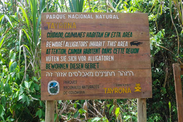
Tayrona National Natural Park is part of the ancestral territory known as the Black Line, home to the four indigenous communities of the Sierra Nevada de Santa Marta (Koguis, Arhuacos, Wiwas, and Kankuamos). These communities view the area as a network of sacred sites, connected both physically and spiritually by invisible energetic threads that embody the material life of nature.
This spiritual connection is reflected in the park’s diverse ecosystems, which include thorny scrub, dry forest, humid forest, high-altitude cloud forests, and coastal ecosystems like beaches, lagoons, mangroves, and rocky shores.
The park covers over 15,000 hectares, with 3,000 hectares of marine areas hosting coral formations, sedimentary bottoms, seagrass meadows, and algal congregations.
Tayrona National Natural Park is home to a rich variety of fauna, with notable species found in its different environments:
Terrestrial Fauna: In the park’s terrestrial areas, a diversity of species can be found, such as jaguars, ocelots, margays, foxes, tapirs, and various monkeys and squirrels.
Avian Fauna: The park is an optimal place for birdwatching, with over 350 species, including condors, solitary eagles, white eagles, royal flycatchers, guans, macaws, and more.
Marine Fauna: The waters surrounding Tayrona National Natural Park harbor a rich marine diversity, including species such as snappers, groupers, moray eels, hawksbill and loggerhead turtles, parrotfish, among others.
Activities
- Natural pools
- Fauna and flora observation
- Recreational photography
- Hiking
- Beach activities
- Birdwatching
- Geological observation
- Diving
How to get there?
From the city of Santa Marta, transportation must be taken to one of the four entrances to Tayrona National Natural Park:
- Bahía Concha: Located in the urban area of Santa Marta, it can be accessed through the neighborhoods of Bastidas and Altos de Bahía Concha. After taking an unpaved road, you reach the entrance gate in about 15 minutes by private vehicle. From there, it’s a 20-minute walk to the main beach. You can also reach the Waikiki and Bonito Gordo sectors by boat.
- Palangana: Situated at kilometer 5 on the Caribbean trunk road towards Riohacha, just before the toll. The drive from this point to the entrance takes about 5 minutes. In Palangana, visitors can explore attractions like Gayraca Beach, Neguanje, Playa del Muerto (also known as “Playa Cristal”), and Cinto. The latter two are accessible by boat. Overnight stays are prohibited, so visitors can only stay during the day.
- Calabazo: Accessed via the Caribbean trunk road towards Riohacha, at kilometer 20. The estimated travel time by private vehicle or urban bus is approximately 35 minutes. From Calabazo, access to Playa Brava, Boca del Saco, and Cabo San Juan del Guía is possible.
- El Zaíno: This is the main entrance to the northeastern sector of the Protected Area. Located 32 km from Santa Marta on the Caribbean trunk road towards Riohacha, it takes about 45 minutes to reach by private vehicle. From El Zaíno, visitors can access the sectors of Cañaveral, Arrecifes, and Cabo de San Juan del Guía.
Los Colorados Flora and Fauna Sanctuary
Location: San Juan Nepomuceno, Bolívar
Access: Charged
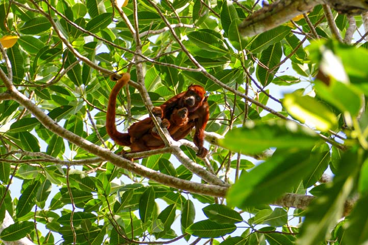
Nestled within the municipality of San Juan Nepomuceno, in the heart of Bolívar department, lies Los Colorados Flora and Fauna Sanctuary. This natural haven was officially designated as a Protected Area on June 6, 1977, owing its name to the striking red howler monkey—also known as the “Mono colorado.”
Spanning an impressive 1000 hectares, this sanctuary safeguards the last remnants of tropical dry forest in the Colombian Caribbean region. Here, a vibrant tapestry of plant and animal species thrives harmoniously. Notably, it has earned the distinction of being an AICA Zone due to its remarkable birdlife, boasting over 289 recorded avian species, including 45 migratory birds.
Among the diversity of mammals that inhabit the Sanctuary are notable species such as the Puma, the Gatopardo, the red howler monkey, the Tigrillo, the Margay, the white-headed titi monkey, the white-tailed deer, the three-toed sloth, the collared peccary , the striped hog-nosed skunk, the Central American agouti , the anteater and the lowland paca.
Activities
- Hiking
- Birdwatching
- Recreational Photography
- Wildlife Observation
How to get there?
By Land:
For a terrestrial adventure, hop on a bus from any major transportation terminal in Colombia that connects to San Juan Nepomuceno in Bolívar.
By Air:
If you prefer the skies, board a plane from any national airport with connections to Corozal (Sucre), Cartagena (Bolívar), or Barranquilla (Atlántico). From these cities, continue your journey by land to San Juan Nepomuceno.
Once in the municipality, visitors should go to the Protected Area’s Visitor Service Office, located at Carrera 8 # 9-23, in Olaya Herrera Plaza. From this point, they will be guided and accompanied to the sanctuary.
Farallones de Cali National Natural Park
Location: Cali, Valle del Cauca
Access: Charged
Amidst the Andes and the Colombian Pacific, emerges the biodiverse rocky massif known as the Farallones de Cali, with rugged formations and varied topography. Encompassing an area of 196,429 hectares, it constitutes the most recent rocky formations of the western range of the Andes.
The Farallones are a biological treasure with high diversity and endemism, serving as an in-situ genetic bank that safeguards natural heritage. It offers various benefits and services such as education, research, monitoring, recreation, and ecotourism, making it a prominent destination for flora and fauna observation.
The park harbors an impressive diversity of birdlife with 626 species, including the Andean cock-of-the-rock, the Colombian Chachalaca, the Baudo guan, the multicolored tanager, the Pacific parrotlet, the Andean condor, among others.

As regards amphibians, 111 species have been recorded, including representative and endemic specimens such as Lehmann’s Poison Frog, Anchicayá Poison Frog, Ruiz’s Goblin Frog and the Glass Frog.
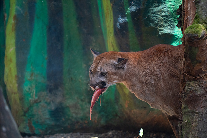
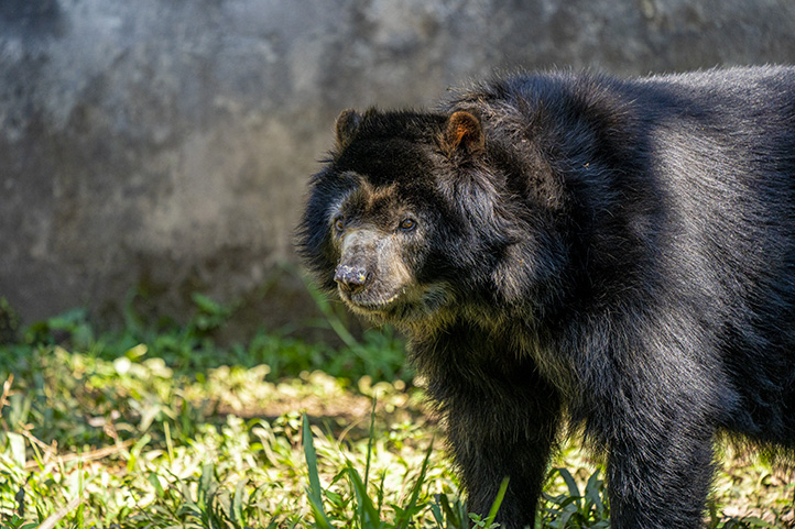
In reptiles, there are 75 documented species, of which 8 are of medical importance because they are venomous snakes, such as the bell pepper snake, the warty snake and the eyelash viper. Finally, 98 species of mammals have been identified, including the Andean bear and the Puma.
Activities
- Fauna and flora observation
- Hiking
- Bird watching
- Recreational photography
How to get there?
From San Buenaventura University, continue along the Cali-Pance road until you reach the Vorágine Sector. Follow the route to the head of the Pance district. From there, take a paved road to the El Pato sector. Then, continue on foot along the trail next to the river until you reach the park.
Gorgona National Natural Park
Location: Cauca
Access: Charged
Gorgona Natural National Park stands out as a small paradise of biodiversity. The lush tropical rainforest cascades from misty summits down into the intensely blue waters.
This park includes two main islands, Gorgona and Gorgonilla, named by the explorer Francisco Pizarro in 1527. Initially used as a high-security prison for 25 years, the archipelago saw its penal function ended in 1984 due to a campaign led by scientists, environmental advocates, and human rights defenders. As a result, the Park was established to protect a significant stretch of the adjacent marine area and its vital ecosystems.
Gorgona National Natural Park preserves a remarkable biological diversity, housing 18 species of corals, 19 types of algae, 108 marine invertebrates, 74 reef fish species, 121 fish species, 11 amphibian species, 56 reptile species, 168 bird species, 18 terrestrial mammal species, and 15 marine mammal species. Noteworthy among these are endemic species like native land snails, freshwater crabs, scorpions, blue lizards, and two butterfly species: Mesosemia zonalis gorgonensis and Cattlehearts.
Activities
- Beaches
- Wildlife and flora observation
- Hiking
- Light boating
- Geological observation
- Recreational photography
- Diving
- Whale watching
How to get there?
From the port of Buenaventura, you can arrange an express boat service for a round trip. For groups larger than 10 people, the journey typically takes about 4 hours.
Alternatively, there is a coastal boat option to Satinga municipality from the port, which takes approximately 12 hours (requires more than two people for the boat to depart). Reservations for maritime transport should be made in advance through local tour operators, with costs varying based on the number of passengers aboard.
Utría Natural National Park
Location: Chocó
Access: Charged.
Utría Natural National Park is a treasure of biodiversity and natural beauty located in the Colombian Pacific region. With an approximate extension of 54,300 hectares, this nature sanctuary is characterized by its lush tropical rainforest, pristine beaches, mangroves, and a rich marine diversity.
The area plays a crucial role as a breeding and initial growth habitat for various species of whales, including humpbacks, orcas, and sperm whales. In addition, endangered sea turtles such as the loggerhead, hawksbill, and leatherback carry out their nesting on its sandy beaches.
In terms of birds, the region hosts a notable diversity with around 270 recorded species. Among them are regional endemics like the Chocó tinamou, a locally threatened species. Also prominent are emblematic birds such as the harpy eagle, the green macaw, and the great curassow.
Among mammals, species considered at low risk of extinction are present, such as the anteater, jaguar, otter, night monkey, spider monkey, and black howler monkey.
Activities
- Beach
- Light boating
- Whale watching
- Hiking
- Wildlife and flora observation
- Recreational photography
- Diving
How to get there?
From Buenaventura, you can travel to destinations like Bahía Solano, Nuquí, or El Valle using coastal vessels, which take about 26 hours, or authorized boats (motonaves) that operate every Tuesday. These motonaves depart from Buenaventura via Juanchaco, Nuquí, and Bahía Solano, with a travel time of approximately 9 hours.
From Bahía Solano, you have the option to take a bus to the village of El Valle, a journey lasting about 40 minutes. From there, you can hike to the park through a trail in the tropical rainforest, which takes approximately 3 hours.
To access the El Valle – Utría trail, it’s mandatory to be accompanied by a natural and cultural interpreter, as well as a local guide.
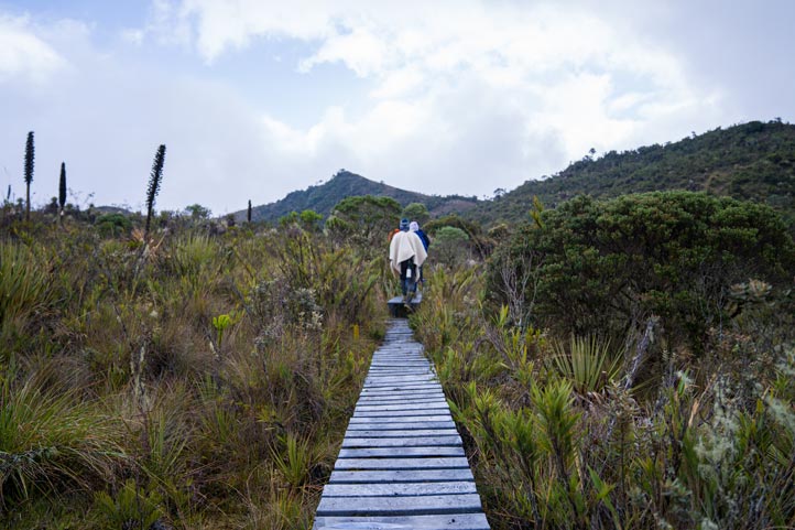
Sierra de La Macarena Natural National Park
Location: Macarena, Meta
Access: Charged
The Sierra de La Macarena Natural National Park was established from the La Macarena Biological Reserve in 1948. This park covers a vast geological uplift extending westward from the Guiana Shield, approximately 130 kilometers long and 30 kilometers wide, known as “Sierra de La Macarena.”
With an area of 629,280 hectares, the park presents a variety of ecosystems, including humid rainforests, floodable forests, shrubs, and Amazonian savanna herbaceous vegetation.
It is distinguished as an exceptional area due to its isolated mountain range condition, suggesting the existence of unique species and significant diversity in flora and fauna. Additionally, archaeological evidence can be found along the Duda and Guayabero rivers, including petroglyphs and pictograms left by indigenous cultures that inhabited the area.
Here you can find a variety of animals, including: Anteaters, Jaguars, Cougars, Deer, 8 species of monkeys, 500 species of birds, 1200 species of insects, and 100 species of reptiles. Furthermore, the park is known for its unique flora, featuring over 50 species of orchids and 2000 other flowers.
Activities
- Hiking
- Geological observation
- Cultural tourism
- Wildlife and flora observation
- Pictogram observation
How to get there?
Start from Bogotá and head towards Granada municipality in Meta department. Continue towards San Juan de Arama and when you reach the “Y” junction, take the road towards Mesetas municipality. Keep going until you reach Curia hamlet, then turn onto the trail leading to the Cerrillo sector.
Chingaza Natural National Park
Location: La Calera, Cundinamarca
Access: Charged
Chingaza Natural National Park, located in the eastern Andes mountain range northeast of Bogotá, is a valuable natural and cultural treasure in the center of Colombia. It encompasses 11 municipalities, 7 in Cundinamarca (Fómeque, Choachí, La Calera, Guasca, Junín, Gachalá, and Medina) and 4 in Meta (San Juanito, El Calvario, Restrepo, and Cumaral).
This park harbors ecosystems such as high Andean, sub-Andean, and moor forests, serving as a refuge for a varied and majestic fauna. Within an altitudinal range from 800 to 4000 meters above sea level, the park’s fauna adapts to different topographical conditions and plant formations.
Among the 101 recorded mammals are the Andean bear, the white-tailed deer, the red deer, and the Puma (Puma concolor). Additionally, 531 species of birds have been identified, including the bearded helmetcrest hummingbird, the Bogotá rail, the Andean condor, and the Andean cock-of-the-rock.
Regarding herpetofauna, 49 species of amphibians and 32 species of reptiles have been documented, such as the harlequin frog, the rain frog, the collared lizard, and the gecko.
Activities
- Mountain biking
- Stargazing
- Recreational photography
- Wildlife and flora observation
- Hiking
- Geological observation
- Bird watching
- Fishing
How to get there?
Starting from downtown La Calera, the route passes near the Cementos Samper ruins and the Buenos Aires hamlet. After traveling 22 kilometers, you’ll reach the Piedras Gordas Park service post. Continuing for another 28 kilometers, you’ll arrive at the Monterredondo Administrative Center.
Los Nevados Natural National Park
Location: Murillo, Tolima
Access: Charged
Los Nevados Natural National Park is located at the heart of the Coffee Axis, in the northern volcanic complex that includes the Nevado del Ruiz, with its craters La Olleta and La Piraña, the Nevado de Santa Isabel, the Nevado del Tolima, and the Paramillos of Cisne, Santa Rosa.
This Protected Area was established in 1974 with the purpose of preserving ecosystems of great global importance, such as three of the few glaciers that still persist in the country, as well as super-moor, moor, high Andean wetlands, and high Andean forests.
Within the park, there are several species of birds, including the snowy parakeet, parakeet, Andean condor, Andean condor, Brown-banded antpitta, Andean duck, crested eagle, red-headed partridge, golden-plumed parakeet, and the moor hummingbird or white-bearded helmetcrest, which is endemic to the region and unique in the world.
In terms of mammals, the fauna includes species such as mountain tapir, rabbit deer, white-tailed deer, tigrillo and puma. There are also at least 20 species of bats, distributed among insectivores, fruit-eaters and nectar-eaters.
Activities
- Mountaineering
- Bird watching
- Wildlife watching
- Hiking
- Geological observation
- Recreational photography
How to get there?
The main way to get to Los Nevados National Natural Park is through Caldas department, specifically via Manizales and Villamaría. This route follows a network of primary, secondary, and tertiary roads.
From Manizales, take the road towards Bogotá and turn off at kilometer 45, near the La Esperanza tourist stop, towards the intersection of Murillo municipality (Tolima). From there, continue 1000 meters to reach the park entrance via the Brisas sector. Another option is to access the park from Villamaría via the road leading to the La Cueva – Santa Bárbara sector.
More nature tourism experiences in Colombia
Here you will find a list of incredible destinations for hiking and other nature activities in Colombia:
- Best 9 Hiking Regions and 27 Routes in Colombia For Travelers
- Colombian Flowers: The Top 11 Most Representative Species
- Cocoa Guide Colombia – Features & Producers
More recommended hiking trails
- Discover the 7 Best Hiking Routes in Antioquia, Colombia
- The 7 Most Incredible Hiking Routes in Boyacá, Colombia
- The 9 Best Hiking Routes in Cundinamarca, Colombia
- Hiking in Santander, Colombia – 5 Incredible Routes
- How to Hike the Lengerke Trail in Colombia: A Complete Guide
- Hiking in Colombia’s Coffee Region: Top 5 Must-Visit Routes
- Must-Try Hiking Trails in Magdalena, Colombia
- Discover 4 Must-Visit Hiking Trails in Amazonas, Colombia
- The 6 Best Hiking Trails in Tolima, Colombia
- Climbing Tolima Volcano: A Challenging Andes Adventure
- 5 Must-Experience Hiking Routes in Huila, Colombia
- 5 Must-Experience Hiking Trails in Valle del Cauca, Colombia
- 6 Must-Experience Hiking Trails in Cauca, Colombia
- Explore 9 Scenic Trails in Eastern Plains, Colombia
- Hiking in Colombia: Checklist of 23 Essential Items to Bring
- Top 9 Best Places to See Animals in Colombia
