
Updated on 04/17/2024
Dear reader,
I would also like to recommend our Colombia travel guide, which provides a perfect overview of the tourist attractions in Colombia. Enjoy reading it!,
Colombia is a country full of hidden treasures. In this blog, I will take you to explore the places in Colombia that UNESCO has honored with its prestigious title of World Heritage.
- San Agustín Archaeological Park.
- Los Katíos National Natural Park.
- Historic Center of Santa Cruz de Mompox.
- Tierradentro Archaeological Park.
- Malpelo Fauna and Flora Sanctuary.
- Coffee Cultural Landscape.
- Qhapaq Ñan, Andean Road System.
- Chiribiquete National Park – “The Maloca of the Jaguar”.
- Historic Center of Cartagena.
Content
San Agustín Archaeological Park
The San Agustín Archaeological Park, a natural reserve renowned for housing over 500 pre-Columbian sculptures predating Christopher Columbus’s discovery of America, was designated a UNESCO World Heritage Site in 1995 for its historical, cultural, and symbolic significance.
The park spans an area of 2,000 square kilometers (772 square miles), featuring tombs, statues, and stone-carved altars alongside other archaeological pieces crafted by pre-Columbian tribes with high historical value. Some artifacts date back over 2,000 years, constituting an invaluable historical treasure.
Within its 116 hectares (287 acres), the park showcases more than 450 statues, sarcophagi, figures, mounds, and megalithic stone sculptures.
These stone sculptures provide insight into the enigmatic Agustinian culture, whose traditions and beliefs remain not fully understood, shrouding the site in an aura of mystery.
Location
The San Agustín Archaeological Park is situated in the upper basin of the Magdalena River, approximately 2.5 km (1.55 miles) west of the town of San Agustín, in the department of Huila.
Interesting Facts about San Agustín Archaeological Park
- The park has the largest collection of religious monuments and megalithic sculptures in Latin America, making it the world’s largest necropolis.
- Most statues were built between the 1st and 8th centuries AD. The San Agustín culture excelled in art and architecture, making the statues a vivid display of the cultural legacy of that civilization, with much of the park still unexcavated.
- The majority of statues are carved from volcanic tuff, a rock formed from volcanic ash that is easily moldable. Ancient inhabitants knew this, making it easier to carve the statues.
- German archaeologist Konrad Theodor cataloged the San Agustín statues as a “barbaric taste,” believing they were the missing link between pre-Columbian sculptures in the north and south of America. He took 35 sculptures, of which only 3 are now displayed in the Ethnological Museum of Berlin.
- The park features monolithic tombs and sarcophagi (coffins made from a single piece of stone), believed to be used for burying religious or political leaders of the Agustinian culture.
- The park has a network of stone-paved paths built by the culture itself, connecting all areas for easy exploration.
- There is an Archaeological Museum in the park housing a collection of over 110 pieces, including pottery, lithic artifacts, statues, sculpture fragments, and other ancestral objects related to the Agustinian culture.
- The park is located in a transition zone between the Andes and the Amazon rainforest, making it an ideal place for bird and butterfly watching.
Los Katíos National Natural Park
Los Katíos National Natural Park is home to an extraordinary diversity of plants and animals, many of which are endemic and endangered. Designated as a UNESCO World Heritage Site since 1994, it is recognized for its crucial role in the exchange of fauna and flora between Central and South America.
The park spans an area of 72,000 hectares (177,916 acres), comprising two distinct zones: a flat zone of 34,000 hectares (84,015 acres) and a mountainous zone covering 38,000 hectares (93,902 acres).
Within the rich biodiversity of Los Katíos, you can encounter more than 340 bird species, over 100 mammal species, 56 reptile species, 43 amphibian species, and a diverse array of 600 plant species.
Location
Los Katíos National Natural Park is in the northwest of Colombia in the Darién and Urabá regions, in the Chocó and Antioquia departments.
Interesting Facts about Los Katíos National Natural Park
- The name of the park refers to the Embera Katío culture, one of the oldest indigenous cultures in Colombian territory, known for its rebellious nature.
- The park is the only place in South America where many typically Central American species are found, such as the American crocodile, giant anteater, and Central American tapir.
- Approximately 20% of the plant species in the park are endemic to the Chocó-Darién region, meaning they are not naturally found anywhere else in the world.
- The park is home to various ancestral indigenous communities like the Embera, Wounaan, Senu, showcasing the cultural diversity and preservation that has existed in the park for ancient times.
- Los Katíos National Natural Park is the only protected area in this region of Colombia, making it the last refuge for many species that would otherwise face extinction.
- The park offers opportunities for activities such as visiting waterfalls, natural pools, and hiking, providing not only scientific and cultural value but also high tourist value.
Historic Center of Santa Cruz de Mompox
The Historic Center of Santa Cruz de Mompox earned its UNESCO World Heritage Site designation in 1995, attributed to the outstanding preservation of its historic center, which vividly showcases the urban landscape and Spanish colonial architecture from the 17th century.
Situated at an elevation of 33 meters above sea level (108 feet), this municipality is currently inhabited by approximately 45,000 people.
During the Spanish colonization and independence, Santa Cruz de Mompox played a pivotal role in significant events. It served as a prosperous port for transporting goods to the interior of the country.
Location
Mompox is situated on the western bank of one of the branches of the Magdalena River, in the so-called cleared zone of Mompox Island, 271 km from Cartagena, in the Bolívar department.
Interesting Facts about Santa Cruz de Mompox
- The name’s origin comes from the great chief Mompoj of the Kimbay tribe, whose settlement was where the current population resides. The name has changed several times since then (Mompox or Mompós).
- The city was a significant commercial and intercultural logistics reference in the Caribbean during the 17th and 18th centuries, thanks to its strategic location on the Magdalena River.
- Mompox was a town but was elevated to the status of a district in 2017, providing greater administrative and financial autonomy. Districts have closer ties with the government, receiving more resources to preserve their heritage.
- Instead of a typical central square like most Spanish settlements on the continent, Mompox has three squares aligned along the river. Each has its church and corresponds to an ancient indigenous settlement, demonstrating the architectural and cultural uniqueness of the historic center.
- The city is known for its colonial architecture, being one of the best-preserved in the country. It exhibits a blend of architectural styles, including Baroque in ornamentation, Neoclassical in Greek architectural simplicity, and Mudejar incorporating Christian and Muslim elements like bricks and varied ceramics.
- Mompox has been used as a setting for TV series like “La esclava blanca” and books like “Love in the Time of Cholera” by Gabriel García Márquez. These entertainment products have helped raise awareness of the city and its cultural value nationally and internationally.
- Mompox is renowned for its expertise in the intricate art of filigree, the manual crafting of valuable jewelry in gold and silver. These techniques have been passed down through generations and are still preserved.
- The city was an important international religious center during the 17th and 18th centuries due to its large number of churches and convents. Religious people from around the world gathered here.
- The bridge over the Magdalena River connecting Mompox to the main road was built in 2014, measuring over 12 km and being one of the longest bridges in Colombia.
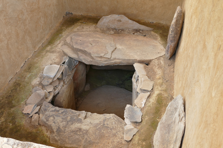
Tierradentro Archaeological Park
Tierradentro Archaeological Park, spanning over 2,085 square kilometers (804 square miles), is an archaeological reserve safeguarding over 160 tombs and 500 stone statues. This site is a custodian of the culture and history of the ancient inhabitants of the Colombian Andes in the southern region during the 6th to 10th centuries AD.
Designated a UNESCO World Heritage Site in 1995, it holds paramount importance as a reservoir of pre-Columbian culture. Presently, it stands as an excellent destination for learning about pre-Hispanic culture.
Similar to San Agustín Archaeological Park, Tierradentro Archaeological Park encapsulates a profound ancestral history that, to this day, has not been fully deciphered.
Location
Tierradentro is located 100 kilometers from Popayán, between the municipalities of Belcazár and Inza in the Cauca department.
Interesting Facts about Tierradentro Archaeological Park
- The park showcases hypogea, underground tombs with depths ranging from 5 to 12 meters (16 to 39 feet), built between 600 and 900 AD. Recognized as the most extensive underground funerary architectural complex in Latin America.
- Pre-Columbian tribes buried elite groups in the hypogea, including warriors, priests, chieftains, and artisans with higher authoritative ranks.
- The hypogea or underground tombs have a shape similar to the ancient houses inhabited by tribes in the region, with stairs, chambers, geometric and zoomorphic figures, suggesting a close symbolic symmetry between the world of the living and the world of the dead.
- The park is a sacred place for the indigenous “Nasa” tribe that inhabited this area for centuries. The Nasa consider the hypogea the dwelling of their ancestors, and the statues are spiritual guardians of the entire territory. They currently participate in park conservation alongside environmental entities.
- The name ‘Tierradentro’ is derived from Spanish explorers who, upon reaching the area, felt as if they had entered the earth’s interior due to the mountainous geography and deep valleys.
- Murals adorning the walls and ceilings of the hypogea feature red and black geometric, zoomorphic, and anthropomorphic designs, representing scenes of daily life, rituals, myths, and mythological beings.
- The park has two museums you can visit: the Archaeological Museum, exhibiting ceramics and metallurgy objects found in excavations, and the Ethnographic Museum, showcasing aspects of the Nasa people’s culture, who still inhabit the region.
- The statues and funeral mounds of this park have designs and shapes similar to those of the San Agustín culture. There is a belief in a close relationship between these two cultures, although it remains a mystery.
Malpelo Fauna and Flora Sanctuary
Designated as a UNESCO World Heritage Site in 2006, Malpelo Fauna and Flora Sanctuary stands as a natural paradise crucial for the survival of marine species facing international threats.
This sanctuary is a habitat for 17 species of marine mammals, 7 diverse marine reptile species, 394 different fish species, and 340 mollusk species.
The island itself spans an area of 1.2 km² (0.46 mi²), and the surrounding marine environment, safeguarded to this day, extends over 4 million hectares.
The underwater topography features precipitous walls, caves, and tunnels that plunge to a depth of 3,400 meters (11,155 feet).
Location
Malpelo is situated 490 kilometers (304 miles) west of the port of Buenaventura, Malpelo Fauna and Flora Sanctuary occupies a remote expanse in the Eastern Tropical Pacific Ocean.
Interesting Facts about Malpelo Fauna and Flora Sanctuary
- Malpelo Island is the pinnacle of a 1,400-kilometer submarine mountain range belonging to the Andean system. It is in a unique geographical position in the entire Eastern Tropical Pacific, including ocean currents, creating high marine biodiversity.
- The sanctuary is the major breeding ground for numerous marine species across the American continent. Here, you can witness predatory species such as sharks, giant groupers, and sailfish, among others.
- The sanctuary is known for sightings of the short-nosed toothless shark, a deep-sea shark, and one of the few places where sightings have been confirmed.
- Malpelo Island is one of Colombia’s and the world’s highly recommended diving sites due to its marine beauty, exploration of underwater caves, steep walls, and marine richness.
- The sanctuary is an essential location for scientific research in marine ecology and biology. Numerous scientific expeditions are carried out to study marine life and oceanographic processes.
- It is also known as the ninth-largest and protected marine fishing area in the world, the largest in the Eastern Tropical Pacific region.
- The sanctuary has no native communities or human colonization. The only presence is that of the National Navy at control points. Visitors are primarily scientific researchers and diving enthusiasts.
Coffee Cultural Landscape
The Coffee Cultural Landscape is a Colombian region where mountain coffee cultivation developed on small traditional estates. It is indeed an example of human adaptation to difficult geographical conditions.
Declared a UNESCO World Heritage Site in 2011, recognizing its natural, economic, and cultural value.
It includes six coffee landscapes and 18 urban centers in the western and central chains of the Andes.
This landscape covers six areas located in 51 municipalities in the departments of Caldas, Quindío, Risaralda, and Valle del Cauca, with an extension of 141,000 hectares (348,621 acres). It has altitudes ranging from 1,000 to 2,000 meters (3,281 to 6,562 feet) above sea level.
Interesting Facts about the Coffee Cultural Landscape
- Here, you’ll find the tallest wax palms on the planet, growing between 60 and 80 meters (197 to 262 feet) tall and only developing between 1,500 and 3,000 meters (4,921 to 9,843 feet) above sea level. The wax palms create the typical picturesque landscape of the coffee axis.
- The “terrace cultivation” technique is an ancestral cultivation method where farmers built stepped terraces to sustainably cultivate coffee. Thanks to this technique, you can enjoy visually stunning and functional landscapes simultaneously.
- The Coffee Cultural Landscape stands out for its natural richness, where you can observe forests, rivers, waterfalls, and thermal springs.
- Urbanized areas are characterized by architecture created by settlers from the Antioquia region, of Spanish influence. They feature adobe and wattle and daub walls, along with clay tile roofs.
- The Coffee Axis is also well-known as “The Coffee Triangle” because it is mainly composed of three departments: Caldas, Quindío, and Risaralda. These three have the most tradition and coffee culture in the country.
- Some areas of the Coffee Axis are characterized by the constant presence of fog or low clouds, enveloping the vegetation. This fog provides moisture to many plants and animals and creates an incredible landscape.
- In this region, U.S. World War II-era Jeep Willys vehicles are used as tourist or cargo transport. It is very common to see them.
- The Coffee Axis produces more than 11 million 60-kilogram bags annually, exporting between 8% and 12% of the total Arabica coffee worldwide.
- This region is a good destination for birdwatching, as it hosts 504 species, both endemic and migratory, from the entire continent. This represents 26% of Colombia and 60% for the entire Andean region. There, you can observe the Andean condor, the largest flying bird in the world.
QhapaqÑan / Andean Road System
Qhapaq Ñan, also known as the Andean Road System, is an engineering and architectural marvel that connects diverse territories and cultures throughout the Andes.
This road was constructed to facilitate communication, transportation, and trade during the Inca Empire in the 15th century.
Qhapaq Ñan was declared a UNESCO World Cultural Heritage in 2014, recognizing its historical, cultural, and social value, as well as its significance for the integration and development of Andean peoples.
It spans 30,000 kilometers (18,641 miles) of roads, bridges, tunnels, stairs, and other elements, traversing six countries: Argentina, Bolivia, Chile, Colombia, Ecuador, and Peru, all of which also have UNESCO recognition.
Location
Extending from the snowy peaks of the Andes, at over 6,000 meters (19,685 feet) in altitude, to the Pacific coast. Specifically, from southern Argentina and Chile to southwestern Colombia in the Nariño department.
Interesting Facts about Qhapaq Ñan Andean Road System
- The road network reached its maximum expansion in the 15th century, stretching across the entire Andean mountain range, surpassing the total length of the Great Wall of China at 21,200 km (13,171 miles).
- The Incas utilized these roads for defensive and military purposes, enabling them to administer and defend their domains throughout the Inca Empire. The empire extended from Colombia to southern Chile, covering an area of 2 million square kilometers.
- The road network was built using a technique called “ushnu,” involving cutting stones into trapezoidal shapes to fit perfectly together without the need for mortar, a substance used in construction since the origins of humanity.
- It is a complex network, connecting all Andean peoples through a series of main and secondary routes, all intricately interwoven.
- It is one of the most extreme geographical terrains globally and was used for centuries by caravans, travelers, messengers, armies, and population groups of up to 40,000 people.
- This road network is the only one on the planet that extends across geographical zones with the greatest ecosystem contrasts, ranging from tropical forests and fertile valleys to moorlands and deserts.
- The road network was an impressive feat of Inca architecture and engineering, initially designed to withstand earthquakes and landslides.
- Current projects are underway to restore the heritage for tourist purposes. It is possible to travel on this network; however, there are sections that unfortunately are unstable for vehicular traffic.
Chiribiquete National Park – “The Maloca of the Jaguar”
Chiribiquete National Park is the country’s largest protected area, covering over 4,200,000 hectares (approximately 16,243 square miles) of forests, savannahs, rivers, and mountains.
It was declared a UNESCO World Heritage Site in 2018, due to its exceptional universal value for nature and culture.
This means it is a unique place in the world that preserves the biodiversity and historical significance of the Colombian Amazon.
The park is home to a large number of species in flora and fauna: 1,801 plant species, 209 butterfly species, over 60 amphibian species, 240 fish species, 60 reptile species, 410 bird species, and 82 mammal species.
Additionally, many of these are endemic and endangered.
Location
Chiribiquete National Park is located in the northwest of the Colombian Amazon region, specifically in the departments of Caquetá and Guaviare.
Interesting Facts about Chiribiquete National Park
- It is considered the home of the jaguar in South America, where this animal is preserved and revered. The park also features rock paintings alluding to the jaguar, which, in indigenous tribes, represents fertility and power.
- This area prevents the release of millions of tons of carbon into the atmosphere. The forests of this park retain around 454 million tons of carbon with their forest cover.
- Chiribiquete National Park is officially the world’s largest tropical rainforest, with an approximate area of 4,268,095 hectares (approximately 16,487 square miles).
- It is one of the most remote places in the world, and due to its inaccessibility and conservation, it is a unique location on the planet.
- The park is one of the few habitats in the country where the harpy eagle and red howler monkey are found, both notable species of the Colombian Amazon. They are currently critically endangered due to habitat loss and poaching.
- Chiribiquete is one of the oldest places in the world, with rock paintings dating back to 20,000 B.C. This makes it the oldest in Latin America and one of the oldest on the planet, with archaeological evidence.
- The rock paintings depict representations of extinct species such as prehistoric horses, giant sloths, and mastodons (ancient relatives of elephants). It is believed that humans living here coexisted with these animals.
- Chiribiquete is a sacred place for indigenous peoples living in voluntary isolation (no contact with groups or individuals), such as the Piratapuyo, Yukuna, Tanimuka, among others. These tribes consider this place the origin of the world and the center of their cosmology.
- Ecotourism is prohibited in this area, so currently, the reserve can only be flown over by helicopter.
Historic Center of Cartagena
The Historic Center of Cartagena is an area of the city where you can find a collection of fortifications, streets, squares, churches, and palaces. This space preserves the colonial style and the history of the Spanish conquest, as well as the independence of Colombia.
It was declared a UNESCO World Heritage Site in 1984 as it is a perfectly preserved legacy and the most complete set of fortifications in South America. It includes bastions, walls, batteries, and forts.
The Historic Center of Cartagena occupies an approximate area of 1.5 km² (about 0.58 square miles), surrounded by an 11-kilometer-long wall built between the 16th and 18th centuries to protect the city from pirate attacks. Today, it is the result of military defense strategies for the city.
Location
The Historic Center of Cartagena is located on the northern coast of Colombia, in a bay facing the Caribbean Sea, in the city of Cartagena, Bolívar.
Interesting Facts about the Historic Center of Cartagena
- The streets of the historic center are paved with large cobblestones called “balaustrades.” These stones were used as ballast on ships, and after being unloaded, they were used to pave the streets.
- The historic center has three entrance gates: the Clock Gate, the San Diego Gate, and the Santo Domingo Gate. They were vital for the defense of the city against invasions during the colonial period.
- The Clock Tower is one of the most important monuments in Cartagena. Built in 1631, it is 30 meters tall and is considered Colombia’s most important clock. It is a significant tourist attraction.
- Plaza de los Coches is a historic square located in the center of Cartagena’s old town. Built in the 17th century, it was the place where African slaves were sold as slaves. Today, the square is a tourist attraction.
- The city was founded in 1533 and was originally called San Sebastián de Calamari. San Sebastián in honor of that saint and Calamari, which in the indigenous language means crab.
- Cartagena was initially a city in Spain, located in the Murcia region. The current name of Cartagena in Colombia is thanks to this Spanish city. It was later changed to Cartagena de Indias to differentiate it from the Spanish city.
- The International Film Festival of Cartagena takes place in the historic city center. It is the first Latin American film festival to exist, with its first edition in 1960.
- The “palenqueras” are fruit vendors who roam the streets of Cartagena’s historic center. They are the most photographed women in Colombia due to their colorful traditional costumes and their ability to balance fruit baskets.
More about Colombia Culture and Events
Explore Colombia’s culture by browsing our blogs.
- The 45 Best and Biggest Festivals in Colombia
- What Language is Spoken in Colombia? – Colombian Language Guide
- Colombian Dialects and Jargons – Guide to Colombian Words for Foreigners
- 31 Typical Colombian Dishes from All Regions You Should Try
- Discover What is the Main Religion in Colombia and its Cultural Impact
- How Easter is Celebrated in Colombia: Traditions and Emblematic Destinations
- Guide to Visiting Churches in Colombia: Manners and Tips for Tourists
- 28 Colombian Brands You Should Know When Visiting Colombia
- The Scariest Places You Can Find in Colombia
- The 7 Most Terrifying Legends in Colombia
- 5 Incredible Indigenous Communities Still Existing in Colombia
- 17 Master Colombian Artisans You Must Know
- Top 9 UNESCO World Heritage Sites in Colombia
- Curious Facts about the 14 Most Important Monuments in Colombia
- Top 12 Most Important Olympic Athletes in Colombia
- Top 10 Colombia Travel Influencers to Follow on Networks
- 24 Powerful Colombian Natural Remedies for Common Ailments
- How is New Year’s Eve Celebrated in Colombia? 15 Traditions You Should Know
- Guide to Colombian Manners and Etiquette Rules for Foreigners in Colombia
- All About Graffiti and Urban Art in Colombia
